
Riozinho
| Município de Riozinho Riozinho |
|||
|---|---|---|---|
 Church of the Lutherans in Riozinho
|
|||
|
|||
| Coordinates | 29 ° 38 ′ S , 50 ° 28 ′ W | ||
 Location of the municipality in the state of Rio Grande do Sul Location of the municipality in the state of Rio Grande do Sul
|
|||
| Symbols | |||
|
|||
| founding | 5th September 1988 town charter (age 31) |
||
| Basic data | |||
| Country | Brazil | ||
| State | Rio Grande do Sul | ||
| ISO 3166-2 | BR-RS | ||
| height | 90 m | ||
| climate | subtropical, Cfa | ||
| surface | 239.6 km² | ||
| Residents | 4330 (2010) | ||
| density | 18.1 Ew. / km² | ||
| estimate | 4653 (July 1, 2019) | ||
| Parish code | IBGE : 4315750 | ||
| Telephone code | (+55) 51 | ||
| Time zone | UTC −3 | ||
| Website | pmriozinho.rs (Brazilian Portuguese) | ||
| politics | |||
| City Prefect | Valério José Esquinatti (2017-2020) | ||
| Political party | MDB | ||
| economy | |||
| GDP | 112,681 thousand R $ 24,459 R $ per person (2017) |
||
| HDI | 0.758 (high) (2010) | ||


Riozinho , officially Portuguese Município de Riozinho , is a municipality in the state of Rio Grande do Sul in southern Brazil . The population was estimated on July 1, 2019 at 4653 inhabitants, who live on a community area of around 239.6 km² and are called Riozinhenser ( riozinhenses ). It is located about 105 km northeast of the capital Porto Alegre .
Neighboring are São Francisco de Paula in the north, Maquiné in the east, Caraá in the southeast, Santo Antônio da Patrulha in the southwest and Rolante in the west. Riozinho was originally part of the Rolante municipality. The municipality is known for the Chuvisqueiro waterfall.
The predominant biome is Mata Atlântica .
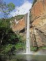
Chuvisqueiro waterfall

Hilly landscape near Chuvisqueiro


Web links
Commons : Riozinho - collection of images, videos and audio files
- City Prefecture website , Prefeitura Municipal (Brazilian Portuguese)
- IBGE to Riozinho. (Brazilian Portuguese, updated statistics).
Individual evidence
- ↑ a b c Riozinho - Panorama. IBGE , accessed July 11, 2020 (Brazilian Portuguese).