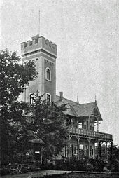
Rittersturz (viewpoint)

The Rittersturz (166 m) is a lookout point near Koblenz . It is a plateau in the Koblenz city forest , south of the Karthaus district , in front of a slate fall that slopes steeply to the Rhine . In the past it has been a court venue, tourist attraction and the site of the Knight Fall Conference of 1948.
location
The Rittersturz is located south of the high-altitude district of Koblenz-Karthause above the Laubach valley , which ends north of the Koblenz brewery on the B 9 . It is overgrown with a high beech forest, only the east side of the plateau slopes steeply to the Rhine. Gray-brown sandstone banks that extend from here to the Königsbach stream are stored between the layers of slate . It is a stratification from the Lower Devonian .
The panorama extends down the Rhine on the left bank of the Rhine over Koblenz-Oberwerth with its stadium to the southern suburb and the neo-Gothic parish church of St. Josef . To the right of the Rhine you can see the districts of Koblenz-Horchheim , Koblenz-Pfaffendorf , Koblenz-Asterstein and Koblenz-Ehrenbreitstein over the Ehrenbreitstein Fortress to the heights of the Westerwald . To the south, the view extends on the left bank of the Rhine to Koblenz-Stolzenfels and on the right bank of the Rhine over Lahnstein with Lahneck Castle to Marksburg over Braubach .
history
According to legend, the name of the lookout point goes back to a knight who fell down the rugged rock face in the Middle Ages. However, this has not been proven historically. Rather, the name "Galgenhell" (Hell / Höll = Halde), which is mentioned on district maps of the 19th century, indicates a place of execution with gallows nearby, which was presumably located below the plateau in the Laubach.
A first forest restaurant on the Rittersturz is occupied in 1892. In 1927 it had to give way to a larger hotel building, which, as can be seen from historical postcards, consisted of a stepped gable wing with a terrace in front and a two-storey two-wing complex with a hipped roof and dormers attached to the side. In 1928 a funicular was built up from the exit of the Laubach valley . A ride on the Rittersturzbahn cable car followed by a stay at the mountain hotel was one of the classic weekend and family outings for the Koblenz family in the prewar period; The Rittersturz Hotel was also a popular conference venue.
The Second World War caused a turning point from which the knight's fall never recovered. The Rittersturzbahn, which reopened after being destroyed in the war in 1951, had become unprofitable due to insufficient visitor numbers and was closed in 1960. The mountain hotel had to be demolished in 1974 for safety reasons because of the risk of rock falls.
Various plans for reconstruction were not implemented, in addition to the unsafe building site (which had already led to the demolition of the old hotel), landscape and nature conservation aspects should speak against it, quite apart from the questionable economic viability.
Fall of the Knight Memorial
In 1978 - a few years after the hotel was demolished - a memorial was erected on the open space through a citizens' initiative. The design by the Koblenz artist Rudi Scheuermann prevailed in a nationwide competition. It is a six-meter-high basalt column, which in its three bundles represents the pillars of the democratic state - legislative, executive and judicial. This was presented to the public on July 8, 1978 as a memorial. For the 60th anniversary of the Rittersturz conference in July 2008, the memorial was extensively restored and the green area around the basalt column redesigned.
Infrastructure
The Rittersturz can be reached on a narrow road from the B 327 via the Kühkopf or from the Rhine, starting from the Laubachtal. At the same time, a hiking trail runs through the Koblenz city forest , which partly coincides with the geological and regional study trail set up by the Geographical Institute of the University of Koblenz .
literature
- Hans Bellinghausen: 2000 years Koblenz. History of the city on the Rhine and Moselle. Boldt, Boppard am Rhein 1971, ISBN 3-7646-1556-7 .
Individual evidence
- ^ Fall of the Knight. regionalgeschichte.net, accessed on April 10, 2017 .
- ↑ https://www.rhein-zeitung.de/region_artikel,-rzkommentar-drahtseilakt-im-welterbe-_arid,106730.html
Coordinates: 50 ° 19 ′ 41 ″ N , 7 ° 34 ′ 56 ″ E


