Ritzing (Moselle)
| Ritzing | ||
|---|---|---|

|
|
|
| local community | Manderen-Ritzing | |
| region | Grand Est | |
| Department | Moselle | |
| Arrondissement | Thionville | |
| Coordinates | 49 ° 26 ' N , 6 ° 28' E | |
| Post Code | 57480 | |
| Former INSEE code | 57585 | |
| Incorporation | 1st January 2019 | |
| status | Commune déléguée | |
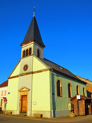
 Saint-Sébastien church |
||
Ritzing (German Ritzingen , Lorraine Réitzingen ) is a commune déléguée in the French commune of Manderen-Ritzing with 167 inhabitants (as of January 1, 2017) in the Moselle department in the Grand Est region (until 2015 Lorraine ).
geography
Ritzing is located about 23 km east of Thionville near the border with Germany at an altitude between 284 and 398 m above sea level, the mean height is 350 m. The area of the Commune déléguée covers 6.15 km².
history
The place has belonged to France since 1661 and was incorporated into the neighboring Launstroff from 1812 to 1880 .
The municipality of Ritzing merged with Manderen on January 1st, 2019 to form the Commune nouvelle Manderen-Ritzing. Since then it has had the status of a Commune déléguée. The municipality of Ritzing belonged to the Arrondissement of Thionville .
Population development
| year | 1962 | 1968 | 1975 | 1982 | 1990 | 1999 | 2007 | 2015 |
| Residents | 194 | 195 | 182 | 154 | 153 | 146 | 132 | 163 |
Web links
- Ritzing on cc3f.fr (French)
