
Launstroff
| Launstroff | ||
|---|---|---|

|
|
|
| region | Grand Est | |
| Department | Moselle | |
| Arrondissement | Thionville | |
| Canton | Bouzonville | |
| Community association | Bouzonvillois-Trois Frontières | |
| Coordinates | 49 ° 26 ' N , 6 ° 30' E | |
| height | 285-407 m | |
| surface | 7.81 km 2 | |
| Residents | 264 (January 1, 2017) | |
| Population density | 34 inhabitants / km 2 | |
| Post Code | 57480 | |
| INSEE code | 57388 | |

Launstroff (German Launsdorf , Lorraine Launschtroff ) is a French commune with 264 inhabitants (as of January 1, 2017) in the Moselle department in the Grand Est region (until 2015 Lorraine ). It belongs to the Arrondissement of Thionville .
geography
Launstroff is located on the border with Saarland , ten kilometers from the border triangle France-Germany-Luxembourg, at an altitude between 285 and 407 m above sea level. The municipality covers 7.81 km².

Place view

Sculpture path


history
The place has belonged to France since 1661. The municipality Launstroff since 1812 include the village Flatten and since 1830 the village scrub forest , with the boundary convention between Prussia and France came to France in 1827 and the 1829th
The neighboring town of Ritzing was incorporated into Launstroff from 1812 to 1880.
Population development
| year | 1962 | 1968 | 1975 | 1982 | 1990 | 1999 | 2007 | 2015 |
| Residents | 288 | 244 | 208 | 177 | 198 | 224 | 250 | 262 |
Culture and sights
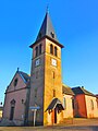
Saint Martin Church
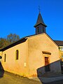
Saint-Bernard chapel in the Flatten district

