
Rettel
| Rettel | ||
|---|---|---|

|
|
|
| region | Grand Est | |
| Department | Moselle | |
| Arrondissement | Thionville | |
| Canton | Bouzonville | |
| Community association | Bouzonvillois-Trois Frontières | |
| Coordinates | 49 ° 27 ' N , 6 ° 20' E | |
| height | 145-300 m | |
| surface | 6.89 km 2 | |
| Residents | 764 (January 1, 2017) | |
| Population density | 111 inhabitants / km 2 | |
| Post Code | 57480 | |
| INSEE code | 57576 | |
 Former Carthusian monastery |
||

Rettel is a French commune with 764 inhabitants (as of January 1, 2017) in the Moselle department in the Grand Est region (until 2015 Lorraine ). It belongs to the Arrondissement of Thionville .
geography
Rettel is located about 15 kilometers northeast of Thionville on the Moselle at an altitude of between 145 and 300 m above sea level. The municipality covers 6.89 km².
history
The place was first mentioned in 620 as Valla Rotovallum . In 800 a sister of Charlemagne founded a Benedictine convent where she is said to have spent the last years of her life. But as early as the 9th century, the monastery became a male monastery, a Benedictine abbey .
In 1431 the abbey was converted into a Carthusian monastery . In the second quarter of the 18th century, the monastery was completely rebuilt based on the model of the Bosserville Charterhouse . After the repeal in the French Revolution , the monastery was demolished.
Together with Lorraine, Rettel fell to France in 1661.
Population development
| year | 1962 | 1968 | 1975 | 1982 | 1990 | 1999 | 2007 | 2015 |
| Residents | 626 | 591 | 583 | 566 | 634 | 684 | 748 | 724 |
Attractions
From the monastery Rettel only few remains have been preserved. There is also a late Gothic house (“Maison de la Dîme”) in typical Lorraine-Metz forms.
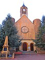
Saint Laurent Church

Remnants of the monastery

late Gothic house ("Maison de la Dîme")


