
Vitry-sur-Orne
| Vitry-sur-Orne | ||
|---|---|---|

|
|
|
| region | Grand Est | |
| Department | Moselle | |
| Arrondissement | Thionville | |
| Canton | Hayange | |
| Community association | Pays Orne Moselle | |
| Coordinates | 49 ° 16 ' N , 6 ° 7' E | |
| height | 157-360 m | |
| surface | 7.61 km 2 | |
| Residents | 3,019 (January 1, 2017) | |
| Population density | 397 inhabitants / km 2 | |
| Post Code | 57185 | |
| INSEE code | 57724 | |
| Website | Vitry-sur-Orne | |
 View of Vitry |
||

Vitry-sur-Orne (German Wallingen ) is a French commune with 3019 inhabitants (as of January 1, 2017) in the Moselle department in the Grand Est region (until 2015 Lorraine ), eleven kilometers southwest of Thionville .
history
First mentioned in 1033 as Vitriacum , Vitry-sur-Orne was completely destroyed in the Thirty Years War and has belonged to France since 1659.
Vitry-sur-Orne includes the district of Beuvange-sous-Justemont ( Bevingen unter Justberg ), a small wine-growing village that was first mentioned in 1124. Until 1907, Clouange was also part of Vitry-sur-Orne. Two other historic districts were Vallange and Huppigny, which were not rebuilt after being destroyed in the Thirty Years War and of which only remains can be found. The name of Vallange was carried over in German to Vitry-sur-Orne.
| year | 1962 | 1968 | 1975 | 1982 | 1990 | 1999 | 2009 | 2017 |
| Residents | 2973 | 2708 | 2671 | 2512 | 2369 | 2332 | 2847 | 3019 |
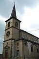
Saint-Etienne church
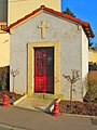
Saint-Nicolas chapel

