
Kerling-lès-Sierck
| Kerling-lès-Sierck | ||
|---|---|---|

|
|
|
| region | Grand Est | |
| Department | Moselle | |
| Arrondissement | Thionville | |
| Canton | Bouzonville | |
| Community association | Bouzonvillois-Trois Frontières | |
| Coordinates | 49 ° 24 ' N , 6 ° 21' E | |
| height | 175-311 m | |
| surface | 17.82 km 2 | |
| Residents | 578 (January 1, 2017) | |
| Population density | 32 inhabitants / km 2 | |
| Post Code | 57480 | |
| INSEE code | 57361 | |

Kerling-lès-Sierck (German Kerlingen , Lorraine Kiirléngen ) is a French commune with 578 inhabitants (as of January 1, 2017) in the Moselle department in the Grand Est region (until 2015 Lorraine ).
geography
The municipality of Kerling is located about 14 kilometers northeast of Thionville and nine kilometers south of the border triangle France-Luxembourg-Germany. The two hamlets to the east of Freching ( Freckingen ) and Haute Sierck ( Obersierck ) also belong to the municipality .
history
The village has belonged to France since 1661, there was a monastery here in the Middle Ages. Until 1955, the official French place name was simply Kerling .
Population development
| year | 1962 | 1968 | 1975 | 1982 | 1990 | 1999 | 2007 | 2015 |
| Residents | 411 | 447 | 422 | 408 | 384 | 439 | 500 | 551 |
Attractions

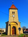
Saint-Jean-Baptiste church

Saint-Joseph chapel in the Freching district
Saint-Nicolas chapel in the Haute Sierck district


