
Merschweiller
| Merschweiller | ||
|---|---|---|

|
|
|
| region | Grand Est | |
| Department | Moselle | |
| Arrondissement | Thionville | |
| Canton | Bouzonville | |
| Community association | Bouzonvillois-Trois Frontières | |
| Coordinates | 49 ° 28 ′ N , 6 ° 25 ′ E | |
| height | 185-431 m | |
| surface | 5.76 km 2 | |
| Residents | 248 (January 1, 2017) | |
| Population density | 43 inhabitants / km 2 | |
| Post Code | 57480 | |
| INSEE code | 57459 | |

Merschweiller (German Merschweiler , Moselle Franconian Meeschweiler / Meeschweller ) is a French commune with 248 inhabitants (as of January 1, 2017) in the Moselle department in the Grand Est region (until 2015 Lorraine ).
geography
The municipality of Merschweiller is located near the border triangle of Luxembourg , France and Germany . In the north it borders on the Saarland Oberperl . The village of Kitzing ( Kitzingen ), a little south of the Manderen Valley, belongs to the municipality .
history
The place has belonged to France since 1661.
Population development
| year | 1962 | 1968 | 1975 | 1982 | 1990 | 1999 | 2007 |
| Residents | 175 | 180 | 170 | 173 | 166 | 164 | 182 |
Culture and sights
There is a great bond between Oberperl and Merschweiller. This is also expressed through joint activities such as the building of the Peace Chapel. The fair in Merschweiller is well attended by the neighbors, especially from Perl, Oberperl and Sehndorf.

Saint-Barthélémy church
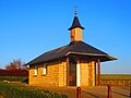
Notre-Dame-de-la-Paix Chapel (Chapel of Peace)

Sainte-Apolline chapel in the Kitzing district


