
Nilvange
| Nilvange | ||
|---|---|---|

|
|
|
| region | Grand Est | |
| Department | Moselle | |
| Arrondissement | Thionville | |
| Canton | Algrange | |
| Community association | Val de Fensch | |
| Coordinates | 49 ° 21 ' N , 6 ° 3' E | |
| height | 193-376 m | |
| surface | 2.81 km 2 | |
| Residents | 4,725 (January 1, 2017) | |
| Population density | 1,681 inhabitants / km 2 | |
| Post Code | 57240 | |
| INSEE code | 57508 | |

Nilvange (German Nilvingen ) is a French commune with 4,725 inhabitants (as of January 1, 2017) in the Moselle department in the Grand Est region (until 2015 Lorraine ). It belongs to the Arrondissement of Thionville .
geography
Nilvange is located a few kilometers west of Thionville at an altitude between 193 and 376 m above sea level. The municipal area covers 2.81 km². The Nilvange junction on the A30 autoroute is south of the town center.
history
Nilvingen was a municipality in the Diedenhofen-West district in the realm of Alsace-Lorraine .
Population development
The place is located in the Lorraine industrial area and is a mining town. Since the decline of mining in Lorraine, the population of Nilvange has been steadily decreasing.
| year | 1962 | 1968 | 1975 | 1982 | 1990 | 1999 | 2007 | 2015 |
| Residents | 9337 | 8136 | 7018 | 5944 | 5583 | 5286 | 4989 | 4796 |
Culture and sights

Château Nilvange
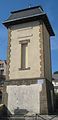
Pigeon tower
Protestant Church

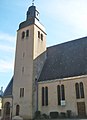
Saint-Jacques-le-Majeur church


Web links
- Community presentation (French)