
Lommerange
| Lommerange | ||
|---|---|---|

|
|
|
| region | Grand Est | |
| Department | Moselle | |
| Arrondissement | Thionville | |
| Canton | Algrange | |
| Community association | Portes de France-Thionville | |
| Coordinates | 49 ° 20 ′ N , 5 ° 58 ′ E | |
| height | 230-327 m | |
| surface | 7.97 km 2 | |
| Residents | 301 (January 1, 2017) | |
| Population density | 38 inhabitants / km 2 | |
| Post Code | 57650 | |
| INSEE code | 57411 | |
| Website | Lommerange | |

Lommerange (German Lommeringen ) is a French commune with 301 inhabitants (as of January 1, 2017) in the Moselle department in the Grand Est region (until 2015 Lorraine ). It belongs to the Arrondissement of Thionville .
geography
Lommerange is about 15 kilometers west of Thionville on the border with the Meurthe-et-Moselle department at an altitude between 230 and 327 m above sea level. The municipality covers 8.06 km². The Conroy River runs along the eastern boundary of the municipality .
history
The place was first mentioned in 1049 as Laumeringa and has belonged to France since 1766.
coat of arms
Description: In blue, a golden crook on the right and a sword with gold designation with a silver blade pointing upwards to the other side and in between a golden six-pointed star . Three (2; 1) silver passion nails on the head and base of the shield .
Population development
| year | 1962 | 1968 | 1975 | 1982 | 1990 | 1999 | 2007 | 2015 |
| Residents | 268 | 262 | 234 | 278 | 282 | 313 | 288 | 274 |
Culture and sights

Saint-Léger church
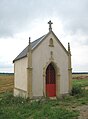
Chapel of Sainte-Apolline

