River Weaver
| River Weaver | ||
|
The River Weaver at Nantwich |
||
| Data | ||
| location | Cheshire ( England ) | |
| River system | River Mersey | |
| Drain over | River Mersey → Irish Sea | |
| source | At Peckforton 53 ° 5 ′ 50 ″ N , 2 ° 41 ′ 37 ″ W. |
|
| Source height | approx. 90 m ASL | |
| muzzle | Port of Runcorn Coordinates: 53 ° 18 ′ 49 " N , 2 ° 44 ′ 55" W 53 ° 18 ′ 49 " N , 2 ° 44 ′ 55" W |
|
| Mouth height | 0.5 m ASL | |
| Height difference | approx. 89.5 m | |
| Bottom slope | approx. 1.1 ‰ | |
| length | 80 km | |
| Catchment area | 1370 km² | |
| Drain |
MQ |
16.94 m³ / s |
| Medium-sized cities | Northwich , Runcorn | |
| Small towns | Nantwich , Frodsham | |
| Communities | Audlem , Wrenbury , Winsford , Sutton Weaver | |
| Ports | Northwich, Runcorn | |
| Navigable | 21 miles from Winsford Bridge | |
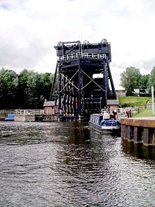
The River Weaver is a river in northern England that curves counterclockwise through the county of Cheshire . Its lower section was made navigable in the 18th century. The most famous structure on the river is the Anderton boat lift from 1875, which connects it to the Trent and Mersey Canal , which is 15 meters higher .
geography
The Weaver rises south of Peckforton on the eastern edge of the Peckforton Hills in western Cheshire. From there it flows first in a south-easterly direction towards the county of Shropshire . At Audlem he turns north and flows through the Cheshire Plain.
The first major city on his way is Nantwich . It then flows further north through Winsford to Northwich. From here it continues to flow in a north-westerly direction. Formerly a tributary of the River Mersey , it now flows in the port of Runcorn into the Manchester Ship Canal, which has been developed for ocean-going ships .
history
Rock salt was mined in what is now the county of Cheshire as far back as Roman times. By the end of the 17th century, numerous salt mines had sprung up around the cities of Northwich , Middlewich , Nantwich and Winsford, which are therefore known as the salt towns . In order to be able to transport the salt more easily, the British Parliament granted permission in 1721 to make the River Weaver navigable. As a result, the 34-kilometer section from the estuary to Winsford Bridge was deepened and partially channeled by a private operating company under the name of Weaver Navigation .
Northwich was the main port city on this navigable stretch. Immediately to the north of it, the Anderton ship lift established the connection to the Trent and Mersey Canal and thus to the rest of the British canal system from 1875.
At Sutton Weaver a river loop was bypassed by a section of the canal, the canal met the river again at Frodsham via a sluice. However, between 1807 and 1810 a short canal called the Weston Canal was built to bypass the difficult and dangerous entrance to the Weaerm Estuary due to tidal currents and to provide a navigable connection to the burgeoning port of Runcorn. This made the Frodsham lock superfluous and closed.
economy
Importance as a traffic route
In the 18th and 19th centuries, large quantities of salt and other goods were transported on the river. But in contrast to most of the British canal system, whose importance for freight traffic declined dramatically with the advent of the railroad in the 19th century, the Weaver remained as a transport route into the 20th century. In 1964, the lower section to Anderton was even expanded to accommodate 57-meter-long ships with a transport capacity of up to 600 tons.
tourism
Just like the British canal system, the navigable section of the River Weaver was increasingly used by recreational boating from the 1970s. After the Anderton ship lift was closed in 1983, however, it was only accessible via the Manchester Ship Canal. Since strict seaworthiness requirements for the boat and crew are placed on this, this led to a dramatic decline in recreational boating on the River Weaver. In addition, there are currently hardly any tourist attractions on the lower reaches, and the Weston Canal runs almost exclusively along industrial plants.
Since the reopening of the Anderton elevator in 2002, however, recreational shipping has been increasing steadily, which is why there are now plans to reopen the canal section to Frodsham and to develop the former shipyard there for tourism.
Web links
- River Weaver Navigation Society
- Jim Shead on the River Weaver
- Lots of information about the river at Dutton Locks
Individual evidence
- ↑ a b National Water Archive , Station Pickerings Cut ( Memento of the original from October 27, 2007 in the Internet Archive ) Info: The archive link was inserted automatically and has not yet been checked. Please check the original and archive link according to the instructions and then remove this notice.
- ↑ History of Weaver Navigation in Priestley's Navigable Rivers and Canals (English)
- ↑ Archived copy ( Memento of the original from April 17, 2009 in the Internet Archive ) Info: The archive link was inserted automatically and has not yet been checked. Please check the original and archive link according to the instructions and then remove this notice.

