Rose lace
| Rose lace | ||
|---|---|---|
|
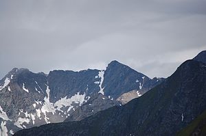
Reichenberger- and Rosenspitze (right) from above the Johannishütte |
||
| height | 3060 m above sea level A. | |
| location | Tyrol , Austria | |
| Mountains | Venediger group | |
| Dominance | 2.2 km → Keesegg | |
| Notch height | 429 m ↓ Daberlenke | |
| Coordinates | 46 ° 59 '18 " N , 12 ° 15' 16" E | |
|
|
||
| First ascent | July 15, 1896 by Ludwig Purtscheller | |
| Normal way | From the Daberlenke over the southern flank and the southwest ridge ( I ) | |
The Rosenspitze is 3060 m above sea level. A. high mountain peaks of the Rosenspitz group in the Venediger group in East Tyrol ( Austria ). It is located in the north-west of East Tyrol on the municipal boundary between St. Jakob in Defereggen and Prägraten am Großvenediger . The Rosenspitze was first climbed on July 15, 1896 by Ludwig Purtscheller via the southwest summit and the southwest ridge.
location
The Rosenspitze is the highest peak in the Rosenspitze, in the center of which it lies. The double summit of the Rosenspitze consists of the main or north-east summit ( 3060 m above sea level ) and the south-west summit ( 3022 m above sea level ). North of the Rosenspitze the Rasbachkarscharte ( 2931 m above sea level ) separates the Rosenspitze from the Großschober ( 3054 m above sea level ), the brittle southeast ridge of the Rosenspitze leads to the Reichenberger Spitze ( 3030 m above sea level ). The southwest ridge of the Rosenscharte runs over the Rosenlenke ( 2809 m above sea level ) down into the valley. The northwest flank of the Rosenspitze falls into the Dabertal, to the south are the so-called Sentenboden and the headwaters of the Trojer Almbach . To the northeast lies the Rasbachkar with the Rasbach, which flows into the Großbachtal.
Promotion opportunities
The normal route to the Rosenspitze leads over the Daberlenke. This is accessible from the Neue Reichenberger Hütte via the Rudolf-Tham-Weg or after a much longer hike from the Clarahütte via the Dabertal. The ascent to the Rosenspitze follows from the Daberlenke over the Sentenboden and the southern flank into the notch between the northeast and southwest summits, before the southeast summit is reached via the southwest ridge ( I ). The south-west summit can be climbed from the Rosenlenke via the south-west ridge ( II ). Furthermore, the Rosenspitze can also be reached as a ridge crossing from the Großschober or from the Reichenberger Spitze (both II ).
Individual evidence
- ↑ Clem Clements, Jonathan de Ferranti, Eberhard Jurgalski , Mark Trengove: The 3000 m SUMMITS of AUSTRIA - 242 peaks with at least 150 m of prominence , October 2011, p. 15. Height of the reference chart according to: Willi End: Alpenvereinsführer Venedigergruppe, Munich 2006, RZ 550.
- ↑ ÖK50; according to TIRIS 3,061 m
literature
- Georg Zlöbl: The three thousand meter peaks of East Tyrol in the Hohe Tauern National Park . Verlag Grafik Zloebl, Lienz-Tristach 2007, ISBN 3-200-00428-2 .
- Willi End / Hubert Peterka : Alpine Club Leader Venediger Group ; Bergverlag Rudolf Rother ; 4th edition 1994; ISBN 3-7633-1242-0 .
- Alpine Club Map 1: 25,000, sheet 36, Venediger Group , ISBN 3-928777-49-1 .

