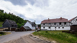
Rosenthal (Leutenberg)
|
Rosenthal
Community Leutenberg
Coordinates: 50 ° 33 ′ 10 ″ N , 11 ° 25 ′ 55 ″ E
|
|
|---|---|
| Height : | 375 m |
| Incorporation : | June 20, 1957 |
| Postal code : | 07338 |
| Area code : | 036734 |
|
Location
|
|
Rosenthal is a hamlet of Leutenberg in the Saalfeld-Rudolstadt district in Thuringia .
location
Rosenthal lies in hilly terrain in the western Sormitztal .
history
The hamlet was first mentioned in a document on April 30, 1417. The name means that it is a former mining settlement with ores smelting. But Rosenthal is also a rural settlement. The place belonged to the Grafschaft Schwarzburg-Leutenberg and after its extinction from 1564 to 1918 to the supremacy of the Grafschaft or the Principality of Schwarzburg-Rudolstadt .
Web links
Commons : Rosenthal - Collection of images, videos and audio files
Individual evidence
- ^ Wolfgang Kahl : First mention of Thuringian towns and villages. A manual. 5th, improved and considerably enlarged edition. Rockstuhl, Bad Langensalza 2010, ISBN 978-3-86777-202-0 , p. 238.
- ↑ Rosenthal on the website of the city of Leutenberg ( Memento of the original from December 13, 2010 in the Internet Archive ) Info: The archive link has been inserted automatically and has not yet been checked. Please check the original and archive link according to the instructions and then remove this notice. Retrieved February 19, 2012
