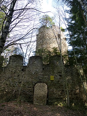
Grünburg ruins (Görtschitztal)
| Grünburg ruins | ||
|---|---|---|
|
Grünburg ruins: Vorwerk with round tower |
||
| Creation time : | 11th century | |
| Castle type : | Höhenburg, hillside location | |
| Conservation status: | ruin | |
| Standing position : | Count, Ministeriale | |
| Place: | Wieting | |
| Geographical location | 46 ° 51 '23 " N , 14 ° 34' 44.6" E | |
| Height: | 1009 m above sea level A. | |
|
|
||
The listed wall remains of the Grünburg ruins are located east of Wieting ( Carinthia ) in the Görtschitztal on the western slope of the Saualpe at 1009 m above sea level. The Hangburg was a twin castle built in the High Middle Ages from the 11th century, which was abandoned in the 17th century and fell into disrepair.
history
Despite its once mighty size, little is known about the history of this castle, primarily due to its remote location and minor strategic importance. The Grünburg was built from the High Middle Ages . At the end of the 11th century it was owned by the Counts of Görz-Tirol and the Bamberg bishops . It was run by their ministerials , who named themselves after the castle. The first Grüneburger recorded in a document was Ulricus de Gruneburch in 1217 . After the counts of Gorizia died out in the 15th century, the castle was built by Emperor Friedrich III. accepted. In 1626 Hans Leonhard von Windischgrätz sat at the castle, which also owned Silberegg and Seltenheim . In 1629 Georg Friedrich von Ambthofen was the owner, and further changes of ownership followed, not known by name.
The Grünburg was probably given up in the 17th century and fell into disrepair. One of the reasons may have been that the mining, which had been in this area for a long time, was no longer profitable at that time. The property eventually became the property of the Eberstein lordship .
Building description
Grünburg was a stately high medieval twin castle. Its ruins are located at a height of a little more than 1000 meters in the middle of poorly maintained forests.
The first Vorwerk , about 100 meters in front of the main castle , consisted in the core of a stately, six-story round tower ( keep ) from the 11th century with 3.2 meters thick walls and a round arched high entrance on the second floor, which is accessible today via a wooden staircase . Only the remains of a polygonal curtain wall are left of this outwork . From the second Vorwerk only small remains exist.
The oldest parts of the stronghold, which was built in the 12th century and today largely collapsed, are located in the south and east of the complex, of which only a remnant of the Bering remains in the south-east. The remnants of a two-storey Romanesque castle chapel are integrated into this bering , which was extended by another storey in the 14th century and expanded to make it more fortified.
The painter Markus Pernhart captured the then still impressive complex in drawings in the middle of the 19th century. Since then, many walls have collapsed and the ruins can hardly be seen from a distance due to the vegetation.
See also
literature
- Dehio Carinthia 2001 . Verlag Anton Schroll & Co., Vienna 2001, ISBN 3-7031-0712-X , p. 250 ff.
- Siegfried Hartwagner : Carinthia. The St. Veit an der Glan district. (= Austrian Art Monograph, Volume VIII). Verlag St. Peter, Salzburg 1977, ISBN 3-900173-22-2 . P. 79.
Web links
- Entry via Grünburg (Görtschitztal) to Burgen-Austria

