
Hohenlandenberg ruins
| Hohenlandenberg | ||
|---|---|---|
 Castle plateau |
||
| Alternative name (s): | Hochlandenberg | |
| Creation time : | around 1300 | |
| Castle type : | Hilltop castle | |
| Conservation status: | Wall remains | |
| Place: | Wila | |
| Geographical location | 47 ° 23 '51.8 " N , 8 ° 51' 55" E | |
| Height: | 794 m above sea level M. | |
|
||

The Hohenlandenberg ruin , also known as the Hochlandenberg , is the ruin of a hilltop castle built on a rocky promontory at 794 m above sea level. M. in the municipality of Wila in the Swiss canton of Zurich .
The castle was probably founded around 1300 by the Lords of Landenberg . It is mentioned in a document in 1300. It stood on an artificially flattened oblong plateau and was protected by two neck ditches in the south and one in the north.
The castle was a neighboring castle of the Landenbergs. In 1344 it was destroyed by the Zurich and Habsburgs, apparently the lord of the castle Beringer II. Von Hohenlandenberg was guilty of robbery and counterfeiting. Beringer was killed on the night of the murder in Zurich .
Stones from the crumbling ruins were used in the construction of the first cotton mill in Turbenthal . The remains of the foundation walls that are visible today were exposed in the winter of 1925/26.
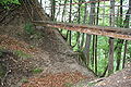
Neck ditch in the north

first neck ditch in the south

second neck ditch in the south

Castle hill

Castle plateau to the north

Castle plateau to the south


Web links
- Martin Leonhard: Landenberg, from. In: Historical Lexicon of Switzerland .
- Burgenwelt: Hohenlandenberg castle site
See also

Alt-Landenberg | Old warehouses | Alt-Regensberg | Alt-Wädenswil | Alt-Wildberg | Alt-Wülflingen | Baldern | Bernegg | Breitenlandenberg | Bubikon | Book | Dättnau | Dowel block | Eglisau | Elgg | Freienstein | Friedberg | Friesenberg | Gamser | Glanzenberg | Greifenberg | Greifensee | Grüningen | Hegi | Hohenlandenberg | Hoh-Wülflingen | Knonau | Kyburg | Langenberg | Running | Liebenberg | Manegg | Maur | Moosburg | Mörsburg | Upper Baliken | Regensberg | Rossberg | Schauenberg | Schnabelburg | Schönenwerd | Sellenbüren | Sünikon | Teufen | Tössegg | Üetliburg | Uster | Wädenswil | Wait | Wetzikon | Wiesendangen | Winturm | Wülflingen | Wulp | Wyden