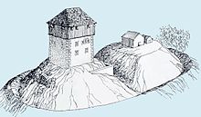
Schauenberg ruins
| Schauenberg ruins | ||
|---|---|---|
|
Castle hill, looking west |
||
| Creation time : | Bronze age | |
| Castle type : | Hilltop castle | |
| Conservation status: | Wall remains | |
| Place: | Hofstetten ZH | |
| Geographical location | 47 ° 27 '36.4 " N , 8 ° 51' 58" E | |
| Height: | 892 m above sea level M. | |
|
|
||
The ruins of the Schauenberg are the ruins of a hilltop castle at 892 m above sea level. M. on the hill of the same name above Elgg or Turbenthal in the canton of Zurich .
history
From 1976 to 1979 the canton archeology of Zurich carried out excavations on the Schauenberg. The investigations were completed with the preservation of the ruins of the medieval castle and the early modern high watch. Based on the archaeological investigations, it is possible to conclude that the Schauenberg has been settled in several phases.
The first tracks
During the Bronze or Iron Age (2200–15 BC) a wall-ditch system with palisades was built around the hilltop. An occupancy in Roman times (15 BC-400 AD) is possible because a Roman key was found in the area of the medieval castle.
The first medieval wooden castle
Around 1200, a wooden structure was built on the west side of the Schauenberg over a cellar sunk into the rock. On the other side of the hilltop, which was not yet subdivided, traces of simple wooden buildings were found. The first medieval castle, a simple noble residence, was protected by ramparts and moats .
Residential tower

Around 1250 the wooden castle was converted into a massive, solidly bricked residential tower . A neck ditch was sunk into the rock across the hilltop . The moat was surmounted on the west side by a wall, which possibly formed a kennel system. The castle was first mentioned in documents in 1260 under the name castro Schowenberc . However, the name Rudolf von Schauenberg appears in written sources as early as 1242. In 1302 the monastery of St. Gallen handed over the feudal lordship over the castle Schauenberg to the servant Walter von Kastell. Thirty years later, the Beringer von Hohenlandenberg is named as the next lord of the castle, but he was accused of robbery and counterfeiting in various chronicles.
It remains to be clarified whether this castle is identical with the castle of Heinrich von Schaunberg, who appears in documents as Heinrich de Stoife, Stoitfe or Stouf after 1158.
The end
When Beringer von Hohenlandenberg committed an offense against the state peace in 1344 , the Austrian officials destroyed the castle together with citizens of Winterthur and Zurich. Since only a small number of ceramics and no mobile objects were found, it is assumed that the castle was already deserted when it was destroyed.
High watch
After 1622, the Zurich authorities were forced to set up a high watch system due to the danger posed by the Thirty Years' War and the conflict between the Catholic and Protestant towns. The signals sent by the Schauenberg could be seen by the Hochwachten Schnabel (Albiskette near Langnau am Albis ), Pfannenstiel , Tämbrig (above Hermatswil ), Üetliberg , Lägern , Zürichberg , Mörsburg , Kyburg , Stammerberg and even Hohenklingen .
Ownership
The upper part of the Schauenberg with the Schauenberg ruins and the triangulation point at 894 meters above sea level belongs to the canton of Zurich, which has leased the entire alp.
literature
- Daniel Hartmann (ed.): The castle Schauenberg near Hofstetten . Fotorotar, Zurich 2000, ISBN 3-905647-29-X .
Web links
- Castle world: Castle Schauenberg
- Office for Spatial Development, Canton of Zurich: Schauenberg Castle near Hofstetten
Individual evidence
- ↑ Archives for Austrian History Volume 94, p. 502
- ^ Community of Hofstetten: Schauenberg


