Saalbach (Gelpe)
| Saalbach | ||
|
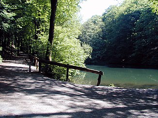
Reservoir of the Hordenbachshammer on the Saalbach |
||
| Data | ||
| Water code | DE : 2736646 | |
| location | NRW , Germany | |
| River system | Rhine | |
| Drain over | Gelpe → Morsbach → Wupper → Rhine → North Sea | |
| source | In Wuppertal - Ronsdorf 51 ° 13 ′ 32 ″ N , 7 ° 10 ′ 57 ″ E |
|
| Source height | 294 m above sea level NN | |
| muzzle | In the Gelpe valley in the Gelpe coordinates: 51 ° 12 ′ 40 ″ N , 7 ° 9 ′ 57 ″ E 51 ° 12 ′ 40 ″ N , 7 ° 9 ′ 57 ″ E |
|
| Mouth height | 182 m above sea level NN | |
| Height difference | 112 m | |
| Bottom slope | 45 ‰ | |
| length | 2.5 km | |
| Catchment area | 2.364 km² | |
| Big cities | Wuppertal , Remscheid | |
|
Ronsdorf Dam 2005 |
||
|
Information sign for a historic site |
||
|
Tributaries and hydraulic structures
|
|||||||||||||||||||||||||||||||||||||||||||||||||||||||||||||||||||||
The Saalbach is a brook in the southern urban area of Wuppertal . As the main tributary, it feeds the Ronsdorf dam .
course
The brook rises in the west of the Ronsdorf district, just a few meters south of the Holthausen location below the Im Saalscheid corridor named after it ; Another source is to the west of the Erich Fried Comprehensive School .
After only a few hundred meters, the Saalbach flows into the Ronsdorf dam . The dam is therefore also called the Saalbach dam . Below the dam, the brook flows through some reservoirs that were created to use the water power of the no longer existing grinding docks and hammer mills . The Saalbach flows into the Gelpe at the Haus Zillertal restaurant .
Location and topography
The Saalbach is located in the south-east of the city of Wuppertal and rises at an altitude of 295 meters above sea level. After a length of about 2450 meters, the stream flows into the Gelpe at a height of 182 meters. Since 1929 it has formed the city limits of Wuppertal to Remscheid in the lower reaches . Before that he fulfilled this function between the formerly independent cities of Ronsdorf and Lüttringhausen .
Art structures and history
The most important engineering structure is the Ronsdorf dam, built between 1898 and 1899 for drinking water. On the lower reaches of the brook there were some metalworking companies, of which mostly only the reservoirs are left. The best known of them at the confluence with the Gelpe is called " Hundsschüppe ". Others were the Hordenbach hammer , the Roodenkotten and the man hammer .
The industrial history trail in the Gelpe-Saalbach area, also known as the “ Historic Gelpe Valley ”, inaugurated in 1980 , explains the individual historical sites and their function on boards.
Natural monument
The source of the Saalbach is protected as a natural monument.
See also
literature
- Egon Viebahn; Hammers and grinding balls in the Gelpetal ; Born publishing house; Wuppertal 1983; ISBN 3-87093-033-0 (extended new edition 2003)
- Günther Schmidt; Hammer and Kotten research in Remscheid , Volume 3: from Gerstau to Haddenbach with Gelpetal and Ibach ; Publisher: Buchhandlung R. Schmitz; Remscheid; 2002; ISBN 3-9800077-3-1
Web links
- Nature reserve "Saalbach (Gelpe)" (W-015) in the specialist information system of the State Office for Nature, Environment and Consumer Protection in North Rhine-Westphalia
Individual evidence
- ↑ a b German basic map 1: 5000
- ↑ a b river basin geographic information system of Wupperverbandes


