Saalfeld (Mühlhausen)
|
Saalfeld
City of Mühlhausen / Thuringia
Coordinates: 51 ° 15 ′ 49 ″ N , 10 ° 31 ′ 42 ″ E
|
|
|---|---|
| Height : | 352 m |
| Residents : | 196 |
| Incorporation : | March 8, 1994 |
| Postal code : | 99974 |
| Area code : | 036029 |
|
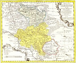
The Eichsfeld and the area of the Free and Imperial City of Mühlhausen with Salfeld (Saalfeld) around 1759 (the map contains some errors: see map description on the picture description page)
|
|
|
Village church
|
|
Saalfeld is a district of the district town of Mühlhausen / Thuringia in the Unstrut-Hainich district .
geography
Saalfeld is on the edge of the Thuringian Basin , several kilometers north of the core city of Mühlhausen. The district is connected to the city and the surrounding area via state road 1016.
history
The village was first mentioned in a document on October 29, 1273. For centuries it was part of the sphere of influence of the Free and Imperial City of Mühlhausen . In 1565 there was a population of 46 in Saalfeld.
In 1802, Saalfeld and Mühlhausen fell to the Kingdom of Prussia , from 1807 to 1813 to the Kingdom of Westphalia ( Canton Dachrieden ) created by Napoleon , and after the Congress of Vienna in 1816 it was assigned to the district of Mühlhausen in the Prussian province of Saxony .
The incorporation to Mühlhausen took place on March 8, 1994. 196 citizens inhabit the place.
church
Individual evidence
- ^ Wolfgang Kahl : First mention of Thuringian towns and villages. A manual. 5th, improved and considerably enlarged edition. Rockstuhl, Bad Langensalza 2010, ISBN 978-3-86777-202-0 , p. 243.
- ↑ Reinhard Jordan (ed.): Chronicle of the city of Mühlhausen in Thuringia. Volume 1: (- 1525). Danner, Mühlhausen 1900, p. 41 .

