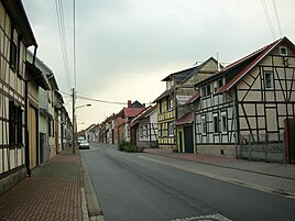
Gormar
|
Gormar
City of Mühlhausen / Thuringia
Coordinates: 51 ° 12 ′ 41 ″ N , 10 ° 29 ′ 28 ″ E
|
|
|---|---|
| Height : | 196 m above sea level NN |
| Residents : | 991 |
| Incorporation : | April 9, 1994 |
| Postal code : | 99974 |
| Area code : | 03601 |
Görmar is a district of the district town of Mühlhausen / Thuringia in the Unstrut-Hainich district .
geography
Görmar is located east of the city center of Mühlhausen on the federal highway 249 to Sondershausen . The municipal area of the district is located in the Thuringian basin near the Unstrut in a predominantly agricultural arable land. There is hardly any forest in the intensely used, undulating terrain. The climate is mild and there is little precipitation with soils mostly affected by groundwater.
history
The first documentary mention of Görmar took place on January 28, 897. For the early medieval history of the region, Görmar was important as the central place of the Germar-Mark named after him . In research it is controversial why this larger complex of Königsgut in north-western Thuringia was named after Görmar and not after the neighboring Mühlhausen (for which Königsgut itself is proven). This suggests that Görmar could have been an important place in older times, especially since the place name is significantly older than the name Mühlhausen from the Franconian period .
see also Görmar Castle .
For centuries, Görmar was part of the sphere of influence of the Free and Imperial City of Mühlhausen . During the Peasants' War on April 29, 1525, the urban poor of Mühlhausen and the rebellious farmers near Görmar founded the United Mühlhäuser and Thuringian Heap , which moved from here to the Franconian rebellion area . In 1565 Goermar (Görmar) had a population of 53.
In 1802 Görmar fell together with Mühlhausen to the Kingdom of Prussia , from 1807 to 1813 to the Kingdom of Westphalia ( Canton Dachrieden ) created by Napoleon , and after the Congress of Vienna in 1816 it was assigned to the district of Mühlhausen in the Prussian province of Saxony .
On April 9, 1994 it was incorporated into Mühlhausen / Thuringia. 991 citizens currently live in the district of the city. The district mayor is Jörg Schreiber.
church
Personalities
- Johann Lorenz Albrecht (born January 8, 1732 in Görmar; † November 29, 1768 in Mühlhausen), composer
Individual evidence
- ^ Wolfgang Kahl : First mention of Thuringian towns and villages. A manual. 5th, improved and considerably enlarged edition. Rockstuhl, Bad Langensalza 2010, ISBN 978-3-86777-202-0 , p. 94.
- ↑ Hans Patze , Peter Aufgebauer (Ed.): Handbook of the historical sites of Germany . Volume 9: Thuringia (= Kröner's pocket edition . Volume 313). 2nd, improved and supplemented edition. Kröner, Stuttgart 1989, ISBN 3-520-31302-2 , p. 148.
- ↑ Lutz Heydick et al. (Ed.): Historischer Führer. Sites and monuments of history in the districts of Erfurt, Gera, Suhl. Urania-Verlag, Leipzig et al. 1978, p. 80 f.
- ↑ Reinhard Jordan (ed.): Chronicle of the city of Mühlhausen in Thuringia. Volume 1: (- 1525). Danner, Mühlhausen 1900, p. 41 .
- ↑ Arrey von Dommer : Albrecht, Johann Lorenz . In: Allgemeine Deutsche Biographie (ADB). Volume 1, Duncker & Humblot, Leipzig 1875, p. 321.

