Sabóia
| Sabóia | ||||||
|---|---|---|---|---|---|---|
|
||||||
| Basic data | ||||||
| Region : | Alentejo | |||||
| Sub-region : | Alentejo Littoral | |||||
| District : | Be yes | |||||
| Concelho : | Odemira | |||||
| Coordinates : | 37 ° 30 ′ N , 8 ° 30 ′ W | |||||
| Residents: | 1152 (as of June 30, 2011) | |||||
| Surface: | 155.42 km² (as of January 1, 2010) | |||||
| Population density : | 7.4 inhabitants per km² | |||||
Sabóia is a municipality in the Alentejo in the district of Odemira in Portugal with 155.4 km² and 1152 inhabitants (as of June 30, 2011); it has a population density of 7.4 inhabitants per km².
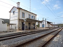
The municipality of Sabóia is located 25 kilometers from the district town of Odemira. In the south the municipality borders on the mountains of Monchique , which already belong to the Algarve ; the area is mountainous throughout and is traversed by the Mira River. In the north the municipality borders on Luzianes-Gare and Santa Maria, which also belong to the district of Odemira . In the west the municipality borders on Boavista dos Pinheiros, São Teotónio and in the east on the municipalities of Santa Clara-a-Velha and Pereiras Gare. Santa Clara-a-Velha has the largest reservoir in the area. Together with Santa Clara-a-Velha, Sabóia has its own train station on the route from Lisbon to Faro.
The name of the place Sabóia is already mentioned in a letter on March 28, 1256 from King D. Afonso III in Odemira .
economy
Forestry is still the main source of income for the local economy today. In earlier times, the wood products were transported on ships across the Rio Mira to the Atlantic coast.
Individual evidence
- ↑ www.ine.pt - indicator resident population by place of residence and sex; Decennial in the database of the Instituto Nacional de Estatística
- ↑ Overview of code assignments from Freguesias on epp.eurostat.ec.europa.eu
Web links
- Map of the Freguesia Sabóia at the Instituto Geográfico do Exército


