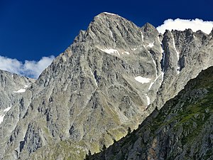
Sackhorn
| Sackhorn | ||
|---|---|---|
|
Sackhorn from the direction of Gfelalp |
||
| height | 3204 m above sea level M. | |
| location | Switzerland | |
| Mountains | Bernese Alps | |
| Dominance | 1 km → Elwertätsch | |
| Notch height | 107 m ↓ Tennbachlücke | |
| Coordinates | 625218 / 143202 | |
|
|
||
| First ascent | not handed down | |
| Development | no | |
| Normal way | via Tennbach Glacier, South Couloir and Northeast Ridge (WS) | |
The Sackhorn is 3204 m above sea level. M. high mountain in the Bernese Alps .
The non-glaciated summit lies on the border of the cantons of Bern and Valais . It is part of the mountain range that rises between the Lötschental in the south and the Gastern valley in the north and extends from the Lötschenpass towards the Petersgrat . The Sackhorn stands out only slightly from the ridge, the lowest point on the Elwertätsch, which is hardly higher, is at the Tennbachlücke at 3,097 m. Other peaks on the same ridge are the Hockenhorn in the west and the Elwertätsch and Birghorn in the east.
On the south side of the Sackhorn lies the Tennbach glacier , which reaches a height of approx. 2900 m, on the north side there is a small, nameless hanging glacier.
There is an unmanned weather station on the summit. The mountain is not developed for tourists and there are no huts in the vicinity.

