
Sainte-Radegonde (Deux-Sèvres)
| Sainte-Radegonde | ||
|---|---|---|
|
||
| local community | Thouars | |
| region | Nouvelle-Aquitaine | |
| Department | Deux-Sèvres | |
| Arrondissement | Bressuire | |
| Coordinates | 46 ° 59 ′ N , 0 ° 15 ′ W | |
| Post Code | 79100 | |
| Former INSEE code | 79292 | |
| Incorporation | 1st January 2019 | |
| status | Commune déléguée | |
| Website | http://www.ville-sainte-radegonde.fr/ | |
 The Thouet at Sainte-Radegonde |
||

Sainte-Radegonde is a commune Déléguée in the French commune of Thouars with 1,828 inhabitants (as of January 1 2017) in the department of Deux-Sèvres in the region Nouvelle-Aquitaine . The inhabitants are called Radegondais .
geography
Sainte-Radegonde is about three kilometers west of Thouars in the Anjou wine region . The Thouet River crosses the Commune déléguée. The village of Sainte-Radegonde was surrounded by the neighboring communities of Sainte-Verge in the north and north-west, Thouars in the east and south-east, Saint-Jacques-de-Thouars in the south and south-east and Mauzé-Thouarsais in the west.
history
On September 14, 1793, the vastly outnumbered republican troops in the valley near Vrines defeated the insurgent troops of the Vendée.
On January 1, 2019, the commune of Sainte-Radegonde was merged with Missé , Mauzé-Thouarsais and Thouars to form the Commune nouvelle Thouars. Since then it has had the status of a Commune déléguée. The commune of Sainte-Radegonde belonged to the Arrondissement Bressuire and was part of the canton of Thouars (until 2015: canton of Thouars-2 ).
Population development
| year | 1962 | 1968 | 1975 | 1982 | 1990 | 1999 | 2006 | 2012 |
| Residents | 796 | 1,130 | 1,810 | 1,984 | 2,020 | 2,027 | 1,973 | 1.919 |
| Source: Cassini and INSEE | ||||||||
Attractions
- Radegundis church with choir from the 12th century
- Vrines Chapel
- Vrines windmill
- Vrines watermill on the Thouet

Radegundis Church

Vrines Chapel
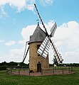
Vrines windmill

Vrines watermill


Viticulture
The place belongs to the Anjou wine region .
Personalities
- Gadifer de la Salle (1340–1415), explorer and mercenary