
Sainte-Verge
| Sainte-Verge | ||
|---|---|---|
|
||
| region | Nouvelle-Aquitaine | |
| Department | Deux-Sèvres | |
| Arrondissement | Bressuire | |
| Canton | Thouars | |
| Community association | Thouarsais | |
| Coordinates | 47 ° 0 ′ N , 0 ° 13 ′ W | |
| height | 39-87 m | |
| surface | 12.83 km 2 | |
| Residents | 1,395 (January 1, 2017) | |
| Population density | 109 inhabitants / km 2 | |
| Post Code | 79100 | |
| INSEE code | 79300 | |

Sainte-Verge is a French commune with 1,395 inhabitants (as of January 1 2017) in the department of Deux-Sèvres in the region Nouvelle-Aquitaine . The municipality belongs to the arrondissement Bressuire and the canton Thouars (until 2015 the municipality belonged to the canton Thouars-2 ).
location
Sainte-Verge is located on the Thouet River , which borders the municipality to the west, about 23 kilometers northeast of Bressuire in the Anjou wine region . Sainte-Verge is surrounded by the neighboring communities of Saint-Martin-de-Sanzay in the north, Louzy in the east, Thouars in the south, Sainte-Radegonde in the southwest and Loretz-d'Argenton with Argenton-l'Église in the west.
Population development
| year | 1962 | 1968 | 1975 | 1982 | 1990 | 1999 | 2006 | 2013 |
| Residents | 961 | 1.007 | 1,135 | 1,242 | 1,202 | 1,329 | 1,453 | 1,427 |
| Source: Cassini and INSEE | ||||||||
Attractions
- Notre-Dame church
- La Forêt Castle
- La Gosselinière Castle
- Blanchard Mill

church

Towers at La Forêt Castle
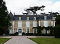
Gosselinière Castle


Viticulture
The place is located in the Anjou wine region .
Parish partnership
A partnership has existed with the Spanish municipality of Hoyos since 2000.