
Saint-Léger-de-Montbrun
| Saint-Léger-de-Montbrun | ||
|---|---|---|
.svg)
|
|
|
| region | Nouvelle-Aquitaine | |
| Department | Deux-Sèvres | |
| Arrondissement | Bressuire | |
| Canton | Le Val de Thouet | |
| Community association | Thouarsais | |
| Coordinates | 47 ° 0 ′ N , 0 ° 7 ′ W | |
| height | 46-105 m | |
| surface | 30.72 km 2 | |
| Residents | 1,264 (January 1, 2017) | |
| Population density | 41 inhabitants / km 2 | |
| Post Code | 79100 | |
| INSEE code | 79265 | |
| Website | http://www.st-legerdemontbrun.fr/ | |

Saint-Leger-de-Montbrun is a French commune with 1,264 inhabitants (as of January 1 2017) in the department of Deux-Sèvres in the region Nouvelle-Aquitaine (before 2016: Poitou-Charentes ). It belongs to the Arrondissement Bressuire and the canton Le Val de Thouet (until 2015: canton Thouars-1 ).
location
Saint-Léger-de-Montbrun is about 58 kilometers northwest of Poitiers . Neighboring municipalities of Saint-Léger-de-Montbrun are Saint-Cyr-la-Lande and Saint-Martin-de-Mâcon in the north, Curçay-sur-Dive in the east and northeast, Pas-de-Jeu in the east, Oiron in the southeast, Taizé-Maulais in the south, Missé in the southwest, Thouars in the west and Louzy in the west and northwest.
Population development
| year | 1962 | 1968 | 1975 | 1982 | 1990 | 1999 | 2006 | 2013 |
| Residents | 879 | 901 | 810 | 987 | 1,183 | 1,174 | 1,162 | 1,252 |
| Source: Cassini and INSEE | ||||||||
Attractions
- Dolmen
- Saint-Léger church
- Rigny Castle
- Beauvais Castle
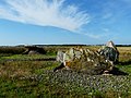
Dolmen Pierre Levée

Saint-Léger church
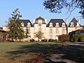
Rigny Castle


Web links
Commons : Saint-Léger-de-Montbrun - Collection of images, videos and audio files