
Salinas Pueblo Missions National Monument
| Salinas Pueblo Missions National Monument | |||
|---|---|---|---|
 |
|||
|
|||
| Location: | New Mexico , United States | ||
| Specialty: | Ruins of Spanish mission churches and Indian pueblos | ||
| Next city: | Mountainair | ||
| Surface: | 4.3 km² | ||
| Founding: | November 1, 1909 | ||
| Visitors: | 34810 (2005) | ||
 |
|||
_location_map.svg)
Salinas Pueblo Missions National Monument is a memorial of the type of National Monuments in the State of New Mexico . The device consists of three spatially separate parts, each of the ruins of the church of a Spanish mission from the early 17th century and the only partially excavated pueblos of Indians by the Spanish missionary preserve should be.
The ruins of Gran Quivira were designated as Gran Quivira National Monument as early as 1909 , while the other two sites, Quarai and Abó , were initially protected as State Monuments of the State of New Mexico in the 1930s . From the 1940s, a merger under federal administration was discussed, but it was not until 1981 that the two state memorials could be integrated into those of the federal government and also placed under the National Park Service . On October 28, 1988, the National Monument was renamed to its current name.
history
The settlements are about 40 kilometers east of the Rio Grande on the eastern flank of the Manzano Mountains . You circle the drainless Estancia basin after whose salt lakes the region and the settlements are named. The oldest traces of human activity go back to 6000 BC. Chr., Permanent settlements can be proven from around the year 700. These are simple pit houses that were found during excavations in 1939/40. From the 12th century pueblo buildings appeared. The residents were in contact with neighboring settlement areas in the Four Corners area and in the early 14th century the Pueblo culture established itself , as it was found by the Spanish conquistadores in the 16th and 17th centuries. The settlements grew together to form integrated structures. In the estancia area, nine of them reached a size that made them play an important role in the Spanish colonization.

The settlements
Of the three preserved pueblos, Abó is the oldest, dating back to around 1100. The building is at the foot of the Manzano Mountains by a stream that feeds from the mountains. There are several springs in the immediate vicinity of the village, only one of which is still water today. The pueblo was expanded many times between 1200 and 1500, but around 1600 only the eastern part of the building, directly on the stream, seems to have been inhabited.
Quarai is located north of Abó, also at the foot of the Manzano Mountains and also has year-round water sources. It wasn't started until around 1300 and may initially have a circular floor plan. It was abandoned by 1500 at the latest and replaced by linear structures. The three-piece buildings of Quarai were the first pueblo the Spaniards reached while exploring the region.
Grand Quivira ( called Las Humanas for most of Spanish times ) is the southernmost of the surviving settlements. It lies in the south of the basin, which is open to the prairies, and its inhabitants were in close contact with the prairie Indians of the Kiowas people . It is named after the mythical gold country Quivira , which the Spaniards were looking for in the region. The building history began here only around 1300 with two settlements around round squares, a type that is also preserved in the Frijoles Gorge in the Bandelier National Monument around 130 km north near Los Alamos . As early as 1400, the residents had largely given up the round buildings and built new, elongated pueblos. In the middle of the 16th century, in addition to the new buildings, one of the round settlements was probably used again.
Of the other six pueblos, three have names from Spanish times: Chililí, Tajique, Tabirá. Three more have only recently been named: LA 200, Pueblo Pardo, Pueblo Colorado. Quarai, Chililí and Tajique in the north of the basin belonged to the Tiwa language family, unlike the southern (including Abó and Gran Quivira) who spoke Piro .
Spanish colonization
Francisco Vasquez de Coronado explored the Rio Grande in 1540–42 in search of gold from Eldorado and Quivira , but did not get to the upper reaches and the tributaries that it would have reached the Salinas Basin. However, he heard about the settlements from Indians. Nevertheless, it was not until the winter of 1581/82 before Capitano Francisco Sanchez Chamuscado and Brother Agustín Rodriguez came to the area from the north and visited the pueblos below the Manzana Mountains. In 1598, Don Juan de Oñate built the first permanent Spanish settlement in Nuevo Mexico. He built his capital in what is now Española and visited all the pueblos in the region. There he had a "contract of submission and vassalage" signed and thus took possession of the villages for the king of Spain and the viceroyalty of New Spain . It is doubtful whether the Pueblo Indians knew the meaning of the declaration and took it seriously.
With Don Oñate, brothers of the Order of the Franciscans (OFM) came and set up Spanish missions throughout the region. In 1610 they founded the city of Santa Fe , which immediately became the new capital of Nuevo Mexico. In the same year they also reached the Salinas Basin. By 1626 five missions were established there, the other four pueblos were covered by a regular visiting service of the padres.
Large areas were used by Spanish farmers who grew food and cotton partly through their own work and partly under the obligation of the Indians. The climatic conditions, especially in the Salinas Basin, were unfavorable and only a few of the farms were successful for a long time.
Both the civil and military administration under the Spanish governor and the Church had extensive authority and their responsibilities were insufficiently delimited. Indian villages were taxed under the encomienda system . After the parallel repartimiento they could be obliged to perform work, formally only against payment, in reality this often did not happen. The Salinas Basin was too poor and barren to attract any more attention.
In the 1660s the missionaries were increased and the Franciscans' churches and conventos were expanded again. The new buildings were powerful symbols of the Church's claim.

The ruins of Abó
The ruins of Quarai
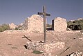
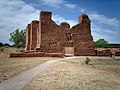
The ruins of Grand Quivira


- In Abó, the church of San Gregorio with the adjacent convent was rebuilt and enlarged. The nave previously had a length of about 20 m, the cloister of the convent was about 15 × 15 m. The choir of the church has now been expanded and lengthened so that the nave was now almost 35 m. Two side altars were created and a large sacristy was added. In a further construction phase, the area of the convent was almost doubled. The former courtyard on the side was almost completely rebuilt.
- At the church and convent Purisima Conception ("for the purest conception") in Quarai, the builders deviated from the basic pattern of the missions. Instead of opening all the rooms onto the cloister, they built a separate block with the monks' cells , which was accessed via a separate corridor. The renovations in the 1660s were only minor here. Adjoining rooms were built in the outer courtyard and the sacristy was slightly rebuilt.
- After a provisional start in the 1630s, Grand Quivira (or Las Humanas ) was initially downgraded to a church for Visita , visits by a priest from the convent of a neighboring village. Your building plan stuck to the basic pattern, but due to local conditions it was created in mirror image and never completed. In addition to the small first church, now known as San Isidro , a separate convent called San Buenaventura was created when the missions were expanded and expanded in several phases until 1667, although the church of the same name was never completed. As early as 1670, the pueblo, the convent and the church were partially burned down during an attack by the Apaches and then abandoned. A third, small and probably only briefly used church was discovered during excavations in 1965-68 in the ruins of the pueblos.
collapse
In the middle of the 1660s a long period of drought set in in northern Mexico, which triggered a variety of conflicts. In addition to food shortages and the poor profitability of Spanish farms, there were attacks by neighboring, predominantly non-settled Indian peoples on the pueblo settlements. There were also minor uprisings by the Pueblo Indians against the Spanish administration.
Around 1670 a withdrawal of the missions from at least some of the settlements was discussed, but that would have given up control and not least tax revenue. In 1671/72 the situation escalated when the church had to distribute food in several pueblos because the settlements could no longer even support themselves due to the drought. The close interweaving of church and state is shown by the fact that a military post was stationed in Abó for this purpose , although the goods to be distributed came from the warehouses of the missions all over Nuevo Mexico . Of course, the soldiers also had to be fed from the supplies.
Grand Quivira was burned down by the Apaches in 1670 and not rebuilt, Abó still existed until 1673 and Quarai had to be given up around the turn of the year 1676/77, the Christian population (Spaniards and some mestizos and assimilated Indians) moved further north to Tajique . This place too had to be abandoned only a few months later when food deliveries from the viceroy from Mexico City did not arrive on time. In 1678 two hundred families of Christianized Indians and a small garrison tried again to colonize Tajique. But they failed either the following year or during the Pueblo uprising in 1680.
Between 1676 and 1680 the viceroyalty set up three supply trains for the starving province on the personal and increasingly urgent initiative of the governor of Nuevo Mexico and the Franciscan brother Francisco de Ayeta, then the willingness to help was exhausted. Sufficient military forces to protect the settlements against the Apache raids were also no longer sent to the north. In 1680, the church sent a petition to King Charles II of Spain, who pledged support. But it was too late for that. Not only had the missions and Spanish settlements in the Salinas basin been abandoned, the administrative structures of the entire province of Nuevo Mexico collapsed until they were resumed on a smaller scale in 1692.
The Indian settlements suffered from a sharp decline in population, but exact figures cannot be estimated. They continued to use the agricultural techniques that the Spaniards had brought with them, as well as some of their tools that they acquired through a sporadic barter . In the 18th century Spaniards only occasionally came through the remote and barren region; between 1762 and 1776 there was a small army base in the south of the area.
It was not until around 1800 that Spaniards settled in the Salinas basin again. Abó and Quarai were the first to be rebuilt because of the springs and the favorable location under the mountains. But they were also more exposed to the ongoing threat from the Plains Indians than the settlements further north. Therefore the Spaniards could not hold on there while Tajique and Torreon grew slowly. Grand Quivira was too far to the south and suffered from the constant lack of water, so that the Spaniards no longer showed any interest in this place. The ruins of the three churches, convents and pueblos were largely preserved. It was not until 1865 that Abó was settled again on a small scale by a single farming family.
The National Monument today
In 1848, after the Mexican-American War , Nuevo Mexico became part of the United States as New Mexico , American settlers, traders, soldiers and adventurers roamed the region with reports and, at the end of the century, photographs of the imposing ruins. In 1909 Grand Quivira was designated a National Monument , and in the 1930s the state of New Mexico placed the ruins of Abó and Quarai under protection. In the same decade, extensive archaeological studies and stabilization of the ruins began.
In 1981 all three ruins were combined and placed under the administration of the federal government, in 1988 the reserve was renamed Salinas Pueblo Missions National Monument . Visitors can visit the respective ruins in all three parts, the central visitor center in Mountainair shows in a museum the history of the Indians, the Spaniards and the first American settlers in the area.
literature
- James E. Ivey: In the Midst of a Loneliness - The Architectural History of the Salinas Missions. National Park Service, Santa Fe / New Mexico 1988 (also online in full text: In the Midst of a Loneliness ; PDF; 5.4 MB)
Web links
- National Park Service: Salinas Pueblo Missions National Monument (official site; English)