
Salvatorkirche (Wroclaw)

The Salvatorkirche in Bohrauer Straße 4 (today ulica Borowska ) in Wroclaw was a neo-Gothic Protestant church that was destroyed during the battle for Wroclaw .
history

Its predecessor, the first Salvator Church, was built in 1568 as a cemetery church for the cemetery laid out in 1541 on the Schweidnitzer Anger, on the bank of the city moat and not far from the later Schweidnitzer Straße . This half-timbered church burned down on November 12, 1854. First of all, the town planning council of Roux prepared two alternative designs for the reconstruction of the church in 1856 (in the arched style and in the neo-Gothic style ). Since the magistrate denied his church construction work to the community representatives , the investment decision was delayed and von Roux's designs were discarded. His successor, Zimmermann , then dealt with another, larger property on the Museum Square on the axis of Tauentzienstrasse . However, as this plot was to be used for other purposes and because of the land acquisition costs, the city council decided in June 1869 to go to the old location. The design by Zimmermann, dated February 20, 1870, shows a compact, three-aisled church made of brick in the neo-Gothic style with a side-lined tower that took up the entire property on the moat. Since this was now lined with magnificent town houses by a dense development, the residents raised claims and declared that they would bear the additional costs of up to 10,000 thalers on a third property . Finally, an extensive area was chosen on the so-called pond fields south of the Upper Silesian train station and north of the towns of Huben and Lehmgruben, which were incorporated in 1867, and the construction decision was confirmed on June 2, 1870. The old property, which had become too small, was converted to Salvatorplatz (today plac Czysty ).
On November 20, 1871, the construction of the new Evangelical Church of Salvator began on the pond fields according to the draft of the city building councilor Zimmermann adapted for the new location and the inauguration could be celebrated on October 19, 1876 .
From 1900 to 1910 Emil Kraeusel was pastor at St. Salvator and from 1935 to 1940 Heinrich Benckert , a member of the Confessing Church .
At the end of the Second World War , the church was badly damaged in the Battle of Wroclaw . It was completely demolished a few years later, like most of the more heavily damaged and not listed Protestant churches.
The property has been used as a central bus station since the early 1990s .
architecture
Except for the missing transept, the neo-Gothic church implemented all the postulates of the Eisenach regulative . The main entrance to the oriented , three-aisled church led through the ground floor of a 66 m high tower in front of the main building volume with a tracery helmet (actually typical for southern Germany) . The five-bay naves were covered with their own saddle roofs. The church was a pseudo-basilica : the central nave was equipped with a high, pointed wooden ceiling, the side aisles had flat roofs. In the aisles and in the first yoke of the central nave there were wooden galleries that were accessible via two staircases on both sides of the tower and two wooden spiral staircases . The central nave was adjoined by a short, pentagonal, vaulted choir , the floor of which was raised by four steps. The same, but lower chapels at the end of the side aisles were not accessible from these, but from the choir. Two side entrances led from the south and the north via wooden vestibules into the church. The church had 1510 seats.
The architecture of the church was based on the Berlin Bartholomäuskirche and Petrikirche .

Land map with church location (1877)
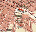
Detail from a city map (1904)


literature
- Hermann Müller: History of the Salvator Church in Breslau and its community . Wroclaw 1898
- Ulrich Bunzel: Origin and Decay of the Protestant Churches in Wroclaw . Munich 1964
- Daria Dorota Pikulska: Carl Johann Christian Zimmermann. Wrocław 2005
Web links
Coordinates: 51 ° 5 '47 " N , 17 ° 1' 59" E