San Antonio Oeste

|
||
| Basic data | ||
|---|---|---|
| Full name: | San Antonio Oeste | |
| location | 40 ° 44 ′ S , 64 ° 57 ′ W | |
| Height above d. M .: | 10 m | |
| Population (2010): | 21,643 | |
|
|
||
| administration | ||
| Province : |
|
|
| Department : | San Antonio | |
| Mayor: | Javier Iud, PJ | |
| Others | ||
| Postal code : | R8520 | |
| Telephone code: | 02934 | |
| San Antonio Oeste website | ||
San Antonio Oeste is a port city in southern Argentina . The capital of the department of San Antonio is located on the Atlantic coast of the province of Río Negro on the Gulf of San Matías and has 21,643 inhabitants (2010 census of the Instituto Nacional de Estadística y Censos (INDEC)). The urban area is extensive, one of the districts is the popular seaside resort of Las Grutas .
location
The Golfo San Matías , a spacious bay on the Atlantic coast, forms the bay of San Antonio at its northern tip , which is bordered by two headlands in the south. On the western headland is San Antonio Oeste, on the eastern ( Punta Villarino ) the smaller San Antonio Este. The area is characterized by the Patagonian steppe, there are isolated table mountains and salt lakes.
climate
The climate is warm and temperate and has the warmest summers on the entire Argentine Atlantic coast with an average of 23 ° C in January, but it looks very rough due to the often blowing Pampero wind. The amount of precipitation is around 250 millimeters, which falls over the whole year.
|
Average monthly temperatures and rainfall for San Antonio Oeste
Source: Servicio Meteorologico Nacional
|
|||||||||||||||||||||||||||||||||||||||||||||||||||||||||||||||||||||||||||||||||||||||||||||||||||||||||||||||||||||||||||||||||||||||||||||||||||||||||||||||||||||||||||||||||||||||||||||||||||||||||||||||||||||||||||||||||
Districts
The city is divided into three districts: the actual San Antonio Oeste (16,265 inhabitants according to the 2010 census), which lies on the west coast of the bay, the port of Puerto San Antonio Este on the opposite east side of the bay (381 inhabitants) and the seaside resort of Las Grutas , 7 km southwest (4,807 inhabitants). The three parts are considered separate localidades (places) in the INDEC statistics , as the development between them is not continuous. The remaining residents live in the countryside. Another district, which does not have the status of such, is the area around the crossroads to Ruta Nacional 3 , three kilometers north of the center, where there are some service providers for travelers (petrol stations, restaurants, workshops, amusement facilities).
San Antonio Oeste
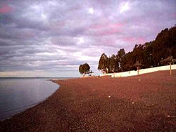
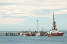
The actual San Antonio Oeste stretches on the Punta San Antonio peninsula for about 5 kilometers along the railway line. The center is about 1 km west of the tip of the peninsula, the oldest buildings, fishermen's houses made of wood and corrugated iron from around 1900, are, however, located directly at the harbor, where a beach has also been created. The harbor, now almost exclusively used by fishing boats, is only in operation at high tide, as the bay is dry at low tide. In the south of the peninsula is the ALPAT alkali factory with its own small port and rail link.
Large parts of the western part of the village are determined by the train station, which has a large warehouse, which is now almost completely closed. The route is only used by a few trains today.
San Antonio Este / Las Conchillas
San Antonio Este is located on the north side of the Punta Villarino peninsula , which borders the bay of San Antonio in the southeast and is shifted about one kilometer to the south of Punta San Antonio, about 3 km from the tip of the peninsula itself. The port facilities take up most of the place. In recent years, the place has expanded to the south coast, where the previously small tourist resort of Las Conchillas is being built on the beach of the same name. At the tip of the peninsula is a nature reserve with a colony of maned seals .
Las Grutas
Las Grutas was the most important seaside resort in Patagonia in 2013 with 38,000 beds and was visited by around 320,000 tourists in the main season in January and February. The district stretches for four kilometers along the coast, which almost invariably takes on the character of a steep coast with grottos, including some sandy and sometimes rocky beaches. Las Grutas, founded in 1964, was initially a weekend resort, but from the 1980s onwards it was transformed into a tourist-oriented seaside resort with a very lively center during the season. Numerous buildings were modeled on traditional Arab architecture, such as the Casablanca business complex . The number of permanent residents, which had quadrupled between 1991 and 2001, increased further from the 2,700 in 2001 to 4,800 in 2010 and thus made up about a fifth of the total population of San Antonio Oeste that year.
history
In 1779 a Spanish expedition explored the coast of the Golfo San Matías, and since they reached the place on the memorial day of Anthony the Great (Spanish: San Antonio Abad ), the name has remained for the bay ever since. However, it was not until 1898 that after the extermination campaign of General Julio Argentino Roca against the Indians, a port settlement was built on the east side of the bay, which was called Puerto del Este and quickly developed into an important export port. A settlement was also established on the west side from 1905. Since the ways to the western town were shorter, the port was moved here in 1905, so that today's San Antonio Oeste was created. After the connection to the railway network (1908), San Antonio was the port from which the materials for the further construction of the railway line to San Carlos de Bariloche , which was completed in 1934, were delivered. After that, the port lost its importance.
As a result of the settlement of new economic sectors and the development of tourism, the population of the city rose by 34.7 percent between the 1991 and 2001 censuses.
Culture and sights
The city has few architectural sights. There are still some huts that are made of corrugated iron and were the predominant house shape at the beginning of the 20th century. The residence of Ingeniero Jacobacci and the fishing port are well worth seeing . The building of the Banco Nación is modeled on the English architecture , there is also a neoclassical town hall (municipalidad). There is also a historical museum . The city is also known for its good fish restaurants.
The Alfonsina Storni Institute of Marine Biology is located in San Antonio . There is also a convention center in Las Grutas.
Economy and Infrastructure
economic sectors
San Antonio is the main port city in the province of Río Negro. The largest port is the east port ( Puerto de San Antonio Este ) , which opened in 1983 and is designed for overseas ships . From there, fruit and other agricultural products produced in the Río Negro valley are shipped. The older Westhafen, which can only be used at high tide, is nowadays used to a limited extent by fishing , which is only of regional importance. There is also a larger fish factory. The economy has been supplemented by the alkali factory Alcalis de la Patagonia ( ALPAT ) since the late 1990s .
Tourism has been gaining in importance in Las Grutas since the 1980s and in San Antonio Este since the early 2000s. The city is also a local service center for sheep farming in the area. The shipping of wool, initially the main activity of the port, is no longer important today.
traffic
The airport Aeropuerto Antoine Saint-Exupéry , named after the famous French writer and pilot , the number of flights completed in the area, located between the actual San Antonio and Las Grutas . LADE served the airport as scheduled until 2009 . As of this year, operations have been limited to general aviation (private and business) and government flights .
Long-distance public transport is mainly handled by buses. San Antonio has a central bus station in the west of the city as well as two stops near the port and right in the center; the various bus routes are spread over these three stops. There is also a bus station in Las Grutas. There are many daily bus connections to the south (to Río Gallegos ), west ( Neuquén , Mendoza ), north ( Córdoba , to Jujuy ) and northeast ( Bahía Blanca , Buenos Aires , Rosario ), as well as a medium-distance bus to Valcheta inland.
The city is located on the railway line between Buenos Aires and San Carlos de Bariloche , but its service between Bahía Blanca and Viedma is interrupted due to the poor condition of the line. The train station is in the west of the city.
In local public transport there is a closely-timed bus route between San Antonio and Las Grutas, and there is also a less frequent bus route to San Antonio Este, where traffic is mainly handled by private boats because the overland route, at 60 kilometers, is five times as long as the sea route. However, there is no regular boat service, which is due to the influence of the tides, as the boat connection is almost dry at low tide.
Water supply
San Antonio Oeste has no natural access to fresh water. The drinking water was originally brought from the nearby town of Valcheta by truck and train. In 1972 the Pomona - San Antonio Oeste Canal was inaugurated and has been providing the city with drinking water ever since. It takes the water from the Río Negro near Pomona in the vicinity of the town of Choele Choel .
Individual evidence
- ↑ Statistical data (1981-1990). Servicio Meteorológico Nacional, accessed August 23, 2012 (Spanish).
- ↑ Más camas, menos turistas ( Memento of the original of September 27, 2013 in the Internet Archive ) Info: The archive link has been inserted automatically and has not yet been checked. Please check the original and archive link according to the instructions and then remove this notice. , fruticulturasur.com, March 7, 2013
- ↑ Historia del Agua en San Antonio Oeste , escuelas.org.ar
- ^ Canal Pomona San Antonio, “El gran aguatero” , VM Noticias, August 21, 2010


