San Carlos (Ichilo)
| San Carlos | ||
|---|---|---|
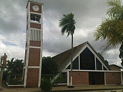
 Church in San Carlos |
||
| Basic data | ||
| Residents (state) | 4620 pop. (2012 census) | |
| rank | Rank 95 | |
| height | 2086 m | |
| Post Code | 07-0402-0103-6001 | |
| Telephone code | (+591) | |
| Coordinates | 17 ° 24 ′ S , 63 ° 44 ′ W | |
|
|
||
| politics | ||
| Department | Santa Cruz | |
| province | Ichilo Province | |
| climate | ||
 Climate diagram Santa Fe de Yapacaní |
||
San Carlos is a country town in the Santa Cruz Department in the South American Andean state of Bolivia .
Location in the vicinity
San Carlos is the second largest city and central place in the district ( Bolivian : Municipio ) San Carlos in the province of Ichilo . The city is located at an altitude of 326 m on the right bank of the Río Surutú , which flows fourteen kilometers downstream at Santa Fe de Yapacaní into the Río Yapacaní , one of the headwaters of the Río Mamoré .
geography
San Carlos is located east of the Bolivian Cordillera Oriental on the edge of the Bolivian lowlands.
The annual average temperature of the region is around 24 ° C (see climate diagram Santa Fe de Yapacaní) and fluctuates only marginally between almost 21 ° C in June and July and a good 26 ° C from November to January. The annual precipitation is about 1800 mm, with monthly precipitation between 60 mm in July and average maximum values of 200 to 300 mm in the summer months from December to February.
Transport network
To the southeast of San Carlos, at a distance of 110 kilometers by road, lies Santa Cruz , the capital of the department.
San Carlos is located on the 1,657-kilometer Ruta 4 highway , which crosses the entire country from Tambo Quemado on the Chilean border in a west-east direction and leads to Puerto Suárez on the Brazilian border. It leads via Cochabamba , Villa Tunari and Yapacaní to San Carlos and on via Santa Cruz , Pailón and Roboré to Puerto Suárez. The road is completely paved from the Chilean border to Pailón, only further on is it unpaved.
population
The population of the village has increased by almost half in the past two decades:
| year | Residents | source |
|---|---|---|
| 1992 | 3 223 | census |
| 2001 | 3 897 | census |
| 2012 | 4 620 | census |
Due to immigration from the Altiplano in the second half of the 20th century, the region has a certain proportion of Quechua population, in the municipality of San Carlos 23.8 percent of the population speak the Quechua language.
Individual evidence
- ^ INE - Instituto Nacional de Estadística Bolivia 1992
- ^ INE - Instituto Nacional de Estadística Bolivia 2001
- ↑ INE - Instituto Nacional de Estadística Bolivia 2012 ( Memento of the original from July 22, 2011 in the Internet Archive ) Info: The archive link has been inserted automatically and has not yet been checked. Please check the original and archive link according to the instructions and then remove this notice.
- ↑ INE social data Santa Cruz 2001 (PDF; 5.2 MB)
Web links
- Relief map of the Santa Cruz region 1: 250,000 (PDF; 7.88 MB)
- Municipio San Carlos - General Maps No. 70402
- Municipio San Carlos - detailed map and population data (PDF 805 kB) ( Spanish )
- Municipio San Carlos - Information from the Santa Cruz Departmental Government ( Spanish )
- Department Santa Cruz - Social data of the municipalities (PDF; 4.99 MB) ( Spanish )
