Sankt Egidi (Raitenbuch)
|
Saint Egidi
municipality Raitenbuch
Coordinates: 48 ° 59 ′ 59 ″ N , 11 ° 8 ′ 15 ″ E
|
|
|---|---|
| Height : | 572-577 m |
| Residents : | 28 |
| Postal code : | 91790 |
| Area code : | 09147 |
Sankt Egidi is a district of the Raitenbuch municipality in the Weissenburg-Gunzenhausen district in Central Franconia .
geography
The hamlet is located on the east side of the Weißenburger Forest south of Raitenbuch and southwest of Reuth am Wald on a terrain that rises towards the forest on the " Gilgenbühl ". From Reuth am Wald and from Raitenbuch there is a local connecting road to Sankt Egidi. From the federal highway 13 , the place can be reached in an easterly direction via the junction in the direction of Raitenbuch.
history
The place probably goes to a royal hunting lodge with a St. Aegidius chapel consecrated back. "Sankt Egidi" means "settlement near the chapel of St. Egidius ”, whose Bavarian name is usually Ilg or Gilg. In 1452 the place was named "St. Gilgen ”mentioned. In a document from 1483, a brother (hermit) at the “St. Gilgen Cape near Bechtal ”the speech; the subjects of the hamlet belonged to the bishop of Eichstätt . The Hermitage was destroyed in the Thirty Years War . In 1726, the vicar general of Eichstätt Jakob Gassner and the Eichstätter citizen son Blettner gave permission to rebuild. The hermitage was located next to the local chapel until secularization . The property was under high court the eichstättischen Pfleg- and Vogt Office Titting-Raitenbuch. The last hermit was Johann Michael Pappler, born in Gersdorf in 1742, who died in 1807.
Sankt Egidi belonged to the municipality Reuth am Wald (this suffix is managed since 1880), with the end of the Old Kingdom in the from the Bishopric of Eichstätt 1802/03 Principality of Eichstätt of Archduke Ferdinand of Tuscany was that at the 1806 kingdom of Bavaria fell . In 1808, Reuth am Wald and Raitenbuch formed the Raitenbuch tax district in the Raitenbuch regional court , and from 1812 in the Greding regional court . Through the municipal edict of 1818, Reuth am Wald with Sankt Egidi again became an independent rural community (rural community). From October 1, 1857, this belonged to the Weißenburg district court , from which today's Weißenburg-Gunzenhausen district developed in 1972. In the course of the municipal reform , Reuth am Wald and Sankt Egidi were incorporated into Raitenbuch on July 1, 1972.
Population development
- 1824: 12 inhabitants, 2 properties
- 1867: 24 inhabitants, 7 buildings
- 1950: 27 inhabitants, 4 properties
- 1961: 19 inhabitants, 4 residential buildings
- 1987: 25 inhabitants
Catholic branch church of St. Giles
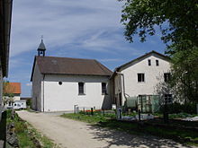
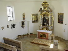
The chapel consecrated to St. Aegidius is a branch church of the Catholic parish of Raitenbuch. The semicircular closed, towerless hall building with a ridge turret in the west was built in 1726 instead of a dilapidated previous building. The two-column baroque altar (around 1630–1650) shows the church patron in the altarpiece, who can also be seen in the antependium and as a figure in a shrine on the left wall of the chapel, and in the elevator God the Father with the globe. Stucco ornaments with bandwork motifs in the style of the early Rococo are attached to the gallery parapet and above the window reveals . In 1976 the slate roof was replaced by a tile roof.
In a path chapel marked 1686 near the local chapel, a wooden statue of a Pietà is placed.
Soil monuments
literature
- Historical Atlas of Bavaria. Part Franconia, Series I, Issue 8. Munich: Commission for Bayer. State history 1960.
- Erich Strassner: rural and urban district of Weißenburg i. Bay. Historical book of place names . Munich: Commission for Bayer. Regional history 1966, no.173.
Individual evidence
- ↑ a b Strassner, p. 58
- ^ A b Benedict Kössler: Gersdorf an der Anlauter. About the culture and past of a village . Regensburg 1962, p. 13
- ↑ a b Information board at the chapel
- ↑ a b c Historical Atlas, p. 254
- ^ Wilhelm Volkert (ed.): Handbook of Bavarian offices, communities and courts 1799–1980 . CH Beck, Munich 1983, ISBN 3-406-09669-7 , p. 593 .
- ^ Joseph Heyberger, Chr. Schmitt, v. Wachter: Topographical-statistical manual of the Kingdom of Bavaria with an alphabetical local dictionary . In: K. Bayer. Statistical Bureau (Ed.): Bavaria. Regional and folklore of the Kingdom of Bavaria . tape 5 . Literary and artistic establishment of the JG Cotta'schen Buchhandlung, Munich 1867, Sp. 1100 , urn : nbn: de: bvb: 12-bsb10374496-4 ( digitized version ).
- ↑ Bavarian State Statistical Office (ed.): Official city directory for Bavaria, territorial status on October 1, 1964 with statistical information from the 1961 census . Issue 260 of the articles on Bavaria's statistics. Munich 1964, DNB 453660959 , Section II, Sp. 835 ( digitized version ).
- ↑ according to the genealogy network ( page no longer available , search in web archives ) Info: The link was automatically marked as defective. Please check the link according to the instructions and then remove this notice.
- ^ Felix Mader and Karl Gröber (arr.): Die Kunstdenkmäler von Bayern. Middle Franconia administrative region. V. City and District Office Weißenburg i. B. Munich: R. Oldenbourg 1932, p. 138
- ↑ Church description on pointoo.de


