Sant Sadurní d'Anoia
| Municipality of Sant Sadurní d'Anoia | ||
|---|---|---|
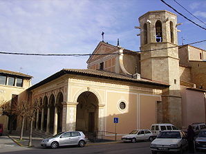
 The Church of Sant Sadurní d'Anoia
|
||
| coat of arms | Map of Spain | |

|
|
|
| Basic data | ||
| Autonomous Community : | Catalonia | |
| Province : | Barcelona | |
| Comarca : | Old Penedès | |
| Coordinates | 41 ° 26 ' N , 1 ° 47' E | |
| Height : | 162 msnm | |
| Area : | 19.02 km² | |
| Residents : | 12,887 (Jan 1, 2019) | |
| Population density : | 677.55 inhabitants / km² | |
| Municipality number ( INE ): | 08240 | |
| administration | ||
| Official language : | Castilian , Catalan | |
| Mayor : | Joan Amat i Solé | |
| Website : | www.santsadurni.org | |
Sant Sadurní d'Anoia is a Catalan city in the province of Barcelona in northeastern Spain . It is in the comarca of Alt Penedès .
Location and climate
The place, built on a chalk cliff on the small river Anoia, borders the mountains of the Garraf in the south and lies in the fertile plain of the Penedès . Wine has been grown here since the 18th century.
Economy and Transport
Sant Sadurni d'Anoia is known for its sparkling wine cellars that produce cava . Over 90% of the Spanish cava production is produced in the numerous aging cellars dug into the chalk cliffs. Well-known brands such as Freixenet and Codorníu have their home here.
Good transport links to the west (Tarragona) and to the east (Barcelona) are provided by both the toll motorway ( AP-7 ) and a railway line. Sant Sadurni d'Anoia is part of the suburban train network ( Cercanías ) of Barcelona.
sons and daughters of the town
- Pedro Gil (* 1980), roller hockey player
- Álex Moreno (* 1993), football player
Web links
- Topographic map and data of the Generalitat of Sant Sadurní d'Anoia
- www.SantSadurni.es
- Information from the municipality (Catalan, Spanish, English)
swell
- ↑ Cifras oficiales de población resultantes de la revisión del Padrón municipal a 1 de enero . Population statistics from the Instituto Nacional de Estadística (population update).

