
Schafberg (Swabian Alb)
| Schafberg | ||
|---|---|---|
.jpg) Schafberg seen from the northern foothills of the Alb |
||
| height | 999.3 m above sea level NHN | |
| location | Zollernalbkreis , Baden-Württemberg , Germany | |
| Mountains | Swabian Alb | |
| Dominance | 2.4 km → Plettenberg | |
| Notch height | 163 m ↓ Scharte to Plettenberg | |
| Coordinates | 48 ° 13 '12 " N , 8 ° 50' 18" E | |
|
||
| rock | White Jura | |

The Schafberg is a 999.3 m above sea level. NHN high mountain on the western edge of the Swabian Alb near Balingen in Baden-Württemberg .
It belongs to the Balingen Mountains and is surrounded by the villages of Roßwangen , Weilstetten (both districts of Balingen ), Tieringen (district of Meßstetten ) and Hausen am Tann . Neighboring mountains are the Plettenberg ( 1001.7 m ) and the Lochenstein ( 963.6 m ).
From the viewpoints Hoher Fels ( 996.5 m ) and Gespaltener Fels ( 999.3 m ) you have a very good view of the surroundings. Hiking trails connect the Balingen Mountains, and the Swabian Alb North Rim Trail and the Main Neckar Rhine Trail also lead over the Schafberg.
The Schafberg is part of the Upper Danube Nature Park .
Picture gallery
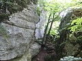
Split rock on Schafberg

The southern part of the Schafberg as seen from the Lochenstein

.jpg)