Schanz (pass)
| Schanz | |||
|---|---|---|---|
|
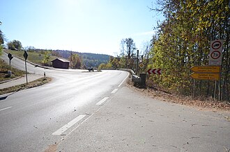
Pass summit, view towards the valley path down to Fornsbach |
|||
| Compass direction | west | east | |
| Pass height | 420 m above sea level NHN | ||
| district | Rems-Murr district | Schwäbisch Hall district | |
| Watershed | Mahdbach → Fornsbach → Murr → Neckar | Fichtenberger Rot → Kocher → Neckar | |
| Valley locations | Murrhardt - Fornsbach | Fichtenberg | |
| expansion | State Road 1066 | ||
| Mountains | Mainhardter Forest / Kirnberger Forest | ||
| particularities | Schanz tunnel of the Murrtalbahn through the foot of the pass | ||
| profile | |||
| Ø pitch | 3.1% (98 m / 3.2 km) | 2.7% (75 m / 2.8 km) | |
| Map (Baden-Württemberg) | |||
|
|
|||
| Coordinates | 48 ° 59 '12 " N , 9 ° 40' 50" E | ||
The Schanz or Schanze is a low mountain pass of the Swabian-Franconian Forest Mountains in the area of the municipality of Fichtenberg in the district of Schwäbisch Hall in north-eastern Baden-Württemberg .
The pass is an important traffic route from the central Neckar area to the north-eastern part of the country. The state road 1066 runs over it from the straight valley axis from the upper Murr , its tributary Fornsbach and the Mahdbach , which in turn converges on it, over to the valley of the Fichtenberger Rot on the east side and continues in it to the Kocher valley . Both neighboring valleys are separated by a narrow mountain ridge on which the Mainhardter Wald in the northwest meets the Kirnberger Wald in the southeast at the pass .
The next major valley town in the West is the Murrhardter village Fornsbach , closer to the western Passfuß is the already Fichtenberg belonging Plapphof rises from which mountain pass in a wide arc in open hallway to its summit. Above it runs in an artificial gap around the eponymous plateau spur Schanz (e) in the southeast; Opposite this is the Harnersberg . On both sides of the pass, low-ranking streets lead off, to the nearby Fichtenberg hamlet of Vorderlangert on the plateau in the south and to the Oberroter hamlet of Glashofen beyond the forest on the Harnersberg on the north. The valley trail in the east falls in a straight line initially through the forest to near the edge of the village of Fichtenberg.
Because the valley locations are quite far from the base of the climbs, the slope values related to their altitude are quite low. The apparently steepest sections are on the Steigenbogen from Plapphof to the top of the pass; On this route of around 1.4 km, the difference in altitude is around 70 meters, corresponding to a mean gradient of around 5%.
The foot of the ridge is crossed in the same direction by the Schanztunnel of the Murrtalbahn from Murrtal into the lower Rot and then into the Kocher valley.
Until the expansion of the state road at the beginning of the 2010s, it led through the Fichtenberg town center and crossed the Murrtalbahn twice over level crossings, which regularly led to large traffic jams in Fichtenberg. The Neutrasse, on the other hand, remains continuously on the south side of the railway line and largely avoids built-up areas; the branch into the upper Rottal (L 1050), which is now a little above the foot of the climb, uses a newly built railway bridge. At the Schanz there are sometimes traffic obstructions in wintry weather.

