
Joke
| Joke | ||
|
|
||
| Data | ||
| Water code | DE : 215472 | |
| location |
Lake Constance Basin
|
|
| River system | Rhine | |
| Drain over | Shoten → Rhine → North Sea | |
| source | South-east of the municipality of Grünkraut in the Wasenmoos nature reserve near Grünkraut 47 ° 44 ′ 17 ″ N , 9 ° 39 ′ 49 ″ E |
|
| Source height | approx. 607 m above sea level NHN | |
| muzzle | West of Weingarten in the Schussen coordinates: 47 ° 48 ′ 16 ″ N , 9 ° 36 ′ 32 ″ E 47 ° 48 ′ 16 ″ N , 9 ° 36 ′ 32 ″ E |
|
| Mouth height | 430.3 m above sea level NHN | |
| Height difference | approx. 176.7 m | |
| Bottom slope | approx. 13 ‰ | |
| length | 13.2 km | |
| Catchment area | 44.4 km² | |
The Scherzach is a small river in the Lake Constance basin in the Ravensburg district in southeastern Baden-Württemberg , which flows into the middle Schussen from the right after a 13 km run to the north and finally west at Weingarten .
geography
course
The Scherzach rises in the Wasenmoos nature reserve near Grünkraut, southeast of the eponymous village of the municipality of Grünkraut in Baden-Württemberg . It flows briefly northwest to Grünkraut and, renatured there, runs through a small village pond in the village.
After this, it flows partially straightened north to the municipality of Schlier , whose main town it touches on the western edge of the village. Then it moves in a valley gully that has been sunk for the first time in a natural bed through the heavily forested Lauratal valley north-north-west to Weingarten , where it turns west. In the town of Weingarten, it is initially led through several canals and finally flows into the middle Schussen on the western edge of the town after a 13.3 km run .
Tributaries and lakes
Direct tributaries and lakes in the course from the origin to the mouth. Lengths and catchment areas according to the official waterway map.
- (Bach from Bechenried), from the right and northeast just before Grünkraut , 1.0 km.
-
 Flows through the village pond in Grünkraut, 0.7 ha.
 - (Bach from Atzenweiler), from the right and south-east across from Grünkraut- Rittel , 1.7 km.
- (Inflow), from the right and south-southeast just after Ritten, 0.8 km.
- (Stream through the Bohlweiher nature reserve), from left and west, 1.2 km.
- (Bach from Richlisreute), from the right and southeast before Schlier , 1.1 km.
- Mühlebach or Schlierbach, from the right and east in Schlier, 1.4 km.
- Furtbach , from the right and a total of south-east near Schlier- Albisreute , 6.7 km and 9.9 km².
- Fenkener Waldbach , from the left and south-southwest shortly after the previous one, 1.0 km.
- → (exit of the engine duct to Weingarten), to the left.
- Zundelbach , from the right and east near Schlier- Zundelbach , 2.3 km.
- Haslachbach , from the left and south-southwest shortly after the previous one, 1.0 km; last crosses the engine lane.
- Hochtobelbach , from the right and east-northeast, 2.2 km. Is the outflow of the Rößler pond .
- ← (backflow of the engine canal to Weingarten), from the left at the first houses in Weingarten , 1.7 km.
- Quiet stream , from the right and east-northeast in Weingarten, 10.8 km and 13.8 km². Arises as a derivative of the Schwarzenbach in Lochmoos running to Wolfegger Ach . With section name sequence Heinrichsbühlkanal → Fuchsentobelkanal → Erbisreuter Bach → Altweiherkanal → Stiller Bach → Schlossmühlbach . A dividing arm of the Altweiher Canal runs through the Rößler Weiher.
photos
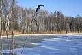
The Wasenmoos nature reserve near Grünkraut in high winter
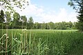
The Wasenmoos nature reserve in early summer

The village pond in Grünkraut with a small island through which the renatured Scherzach flows


Individual evidence
literature
- Topographical map 1: 25,000 Baden-Württemberg, as single sheet No. 8123 Weingarten, No. 8124 Wolfegg, No. 8223 Ravensburg and No. 8224 Vogt
Web links
- Map of the course and catchment area of the Scherzach on: State Institute for the Environment Baden-Württemberg (LUBW) ( information )
- Measuring table sheets in the Deutsche Fotothek :
- 8123 Weingarten from 1914
- 8124 Reute from 1913
- 8223 Ravensburg from 1908
- 8224 Waldburg from 1908