Clever red
|
Clever red
City of Goerlitz
Coordinates: 51 ° 8 ′ 30 ″ N , 14 ° 55 ′ 27 ″ E
|
|
|---|---|
| Height : | about 240 m above sea level NN |
| Area : | 2.5 km² |
| Residents : | 362 (December 31, 2011) |
| Population density : | 145 inhabitants / km² |
| Incorporation : | March 1, 1994 |
| Postal code : | 02827 |
| Area code : | 03581 |
|
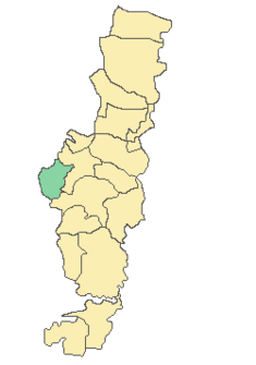
Location of Schlauroth in Görlitz
|
|
Since its incorporation on March 1, 1994, Schlauroth has been the westernmost district of Görlitz .
history
The place was first mentioned in 1285 as Villa Slurath juxta Landiscrone . Over the years the name changed several times. So the place was 1325 Schluroth called 1427 Slaurod and 1567 Schlauret . From January 1, 1972 to June 30, 1984, Schlauroth and Pfaffendorf formed the municipality of Pfaffendorf-Schlauroth.
Schlauroth has 365 inhabitants (as of December 31, 2006).
See also
List of cultural monuments in Schlauroth (as of 2014)
Web links
Wikisource: Schlauroth - Sources and full texts
- Schlauroth in the Digital Historical Directory of Saxony
Individual evidence
- ↑ goerlitz.de: Statistical monthly figures for the city of Görlitz, December 2011 . (No longer available online.) Archived from the original on October 18, 2012 ; Retrieved June 11, 2012 . Info: The archive link was inserted automatically and has not yet been checked. Please check the original and archive link according to the instructions and then remove this notice.

