Rauschwalde
|
Rauschwalde
City of Goerlitz
Coordinates: 51 ° 8 ′ 27 ″ N , 14 ° 56 ′ 45 ″ E
|
|
|---|---|
| Height : | about 200 m above sea level NN |
| Area : | 3.3 km² |
| Residents : | 6061 (Dec. 31, 2011) |
| Population density : | 1,837 inhabitants / km² |
| Incorporation : | 1925 |
| Postal code : | 02827 |
| Area code : | 03581 |
|
Location of Rauschwalde in Görlitz
|
|
|
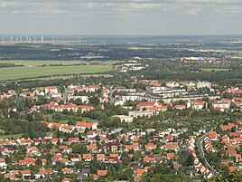
View over Rauschwalde from Görlitz's local mountain - the Landeskrone
|
|
Rauschwalde has been part of the city of Görlitz since it was incorporated in 1925 . The development of the district varies depending on the district, it ranges from Wilhelminian-style buildings and IW64- type apartment blocks from GDR times to private homes. Between 1975 and 1977, five-story apartment blocks with around 1,500 apartments were built west of Karl-Eichler-Strasse around Kopernikusstrasse. It was the second large new housing estate in Görlitz. Most of the blocks have been renovated over the past few years, giving them a friendlier appearance.
history
Rauschwalde was first mentioned as Rushenwalde around 1310 . The former village of Rauschwalde was located around the post mill built around 1780 , which was demolished between 1904 and 1907. The only reminder of them is a replica, which is easily recognizable from Karl-Eichler-Straße, especially at Christmas time.
At the beginning of the 20th century, Rauschwalde had around 800 inhabitants. In 1914 the population rose to almost 1400. This was due to the opening of the freight and marshalling yard in Schlauroth .
In 1915 Rauschwalde became an independent Protestant community. Before it belonged to the parish of Kunnerwitz and before that to the parish of Jauernick . In 1921 the suburb was already connected to the Görlitz tram network .
It was not incorporated into the city of Görlitz until 1925. Rauschwalde had 3063 inhabitants at that time. The city promoted the place and expanded the local schools. The construction of a central sewage system and the expansion or renovation of the streets were carried out in order to offer urban comfort to the former suburb.
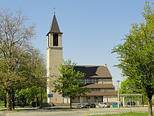
Since the incorporation, one of the most important urban development goals has been the redevelopment of the district on both sides of Reichenbacher Strasse and Reichertstrasse. The construction project was interrupted by the outbreak of the Second World War. Only the Landskronsiedlung in the south of the district on the boundary with Biesnitz was realized. In 1927 the St. Carolus Hospital opened. Another eleven years later, the Protestant community in Rauschwalde received its own church, the Christ Church. It was inaugurated on June 17, 1938.
During the Second World War, there was a forced labor camp from 1942/43 between Johanna-Dreyer-Strasse and Heinrich-Heine-Strasse . After the end of the war it served as a reception camp for refugees from the areas east of the Oder and Lusatian Neisse . In 1968 the first Roman Catholic church was built in Rauschwalde, which was replaced by a new building in 1997.
In 1986 tram traffic was discontinued and replaced by buses, as the rail network gradually deteriorated and the necessary renovation costs were too high.
On January 1, 1999, the moat settlement north of the former marshalling yard was separated from the community of Schöpstal and incorporated into the city of Görlitz. The 479 hectare area of the town moat settlement was added to the Rauschwalde district.
At the end of 2007 the newly built Rauschwalde sports hall was opened . It is the replacement building for the Ulberhalle, which was demolished in 2006. The national handball player Lars Kaufmann was a guest at the inauguration of the hall .
Attractions
economy
- Railway signal construction institute Müller & May: founded in 1890, closed in 1922
- formerly VEB Elektroschaltgerätewerk Görlitz
- former Reichsbahn repair shop Görlitz
- former Schlauroth marshalling yard
traffic
Rauschwalde has its own connection to federal highway 6 . This was rebuilt in 2009 because the old overpass over the railway line to Dresden was dilapidated and is no longer passable.
The Rauschwalder Haltpunkt offers a connection to the regional trains to the surrounding communities and villages, as well as to the Saxon state capital to Dresden Central Station . The stop is served by the Länderbahn (" Trilex ") and the Ostdeutsche Eisenbahn Gesellschaft (ODEG).
The district is connected to local public transport . Several lines of the Görlitzer Verkehrsbetriebe (GVB) and the regional bus Oberlausitz (RBO) cross it.
City bus routes:
- Bus line B: Rauschwalde - Klinikum, Virchowstraße
- Bus line N: Rauschwalde - Biesnitz, Landeskrone (night traffic, runs between 7 p.m. and midnight)
Intercity bus routes:
- Line 130: Görlitz - Reichenbach - Löbau
- Line 136: Görlitz - Schöpstal - Kodersdorf
- Line 137: Görlitz - Markersdorf - Deutsch Paulsdorf
- Line 146: Görlitz - Pfaffendorf - Friedersdorf
Web links
Individual evidence
- ↑ Statistical monthly figures for the city of Görlitz, month December 2011. (No longer available online.) Goerlitz.de, archived from the original on October 18, 2012 ; Retrieved June 11, 2012 . Info: The archive link was inserted automatically and has not yet been checked. Please check the original and archive link according to the instructions and then remove this notice.
- ^ Rauschwalde in the Digital Historical Directory of Saxony
- ↑ The city of Görlitz and its city and districts. (No longer available online.) Goerlitz.de, archived from the original on June 11, 2011 ; Retrieved April 12, 2012 . Info: The archive link was inserted automatically and has not yet been checked. Please check the original and archive link according to the instructions and then remove this notice.
- ↑ a b c The Christ Church Görlitz-Rauschwalde. kkvsol.net, archived from the original on April 13, 2012 ; Retrieved April 12, 2012 .
- ^ Ernst-Heinz Lemper : Görlitz. A historical topography . 2nd Edition. Oettel-Verlag, Görlitz 2009, ISBN 3-932693-63-9 , p. 234 f .
- ^ Ernst Heinz Lemper: Görlitz. A historical topography . 2nd Edition. Oettel-Verlag, Görlitz 2009, ISBN 3-932693-63-9 , p. 237 .
- ↑ Territorial changes. (PDF; 39 kB) statistik.sachsen.de, accessed on July 14, 2012 .
- ↑ New sports hall in Rauschwalde opened . In: Stadt Görlitz (Ed.): Official Gazette of the District-Free City of Görlitz . 2 (Volume 17), January 15, 2008, p. 4 ( ( Page no longer available , search in web archives: goerlitz.de ) [accessed on August 19, 2012]).


