Schmörschwitz
|
Schmörschwitz
Community Rauschwitz
Coordinates: 50 ° 58 ′ 9 ″ N , 11 ° 47 ′ 26 ″ E
|
|
|---|---|
| Height : | 300 m above sea level NN |
| Incorporation : | July 1, 1950 |
| Postal code : | 07616 |
| Area code : | 036692 |
|
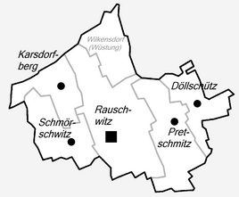
Location of Schmörschwitz in Rauschwitz
|
|
|
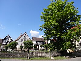
In the town
|
|
Schmörschwitz is a hamlet-like district of the municipality of Rauschwitz in the Saale-Holzland district in Thuringia .
geography
Schmörschwitz is located 500 m west of Rauschwitz. This hamlet was once laid out in the middle of reclaimed arable land for economic reasons . Even 500 m west of the state road 1070, the hamlet has optimal traffic connections to the surrounding area.
history
It was first mentioned in documents in 1145. Rauschwitz and its districts Döllschütz , Karsdorfberg , Pretschwitz and Schmörschwitz are the abbey villages .
Schmörschwitz belonged to the Wettin district office of Eisenberg , which was under the sovereignty of various Ernestine duchies due to several divisions during its existence . In 1826 the place came with the southern part of the Eisenberg district office and the city of Eisenberg from the Duchy of Saxony-Gotha-Altenburg to the Duchy of Saxony-Altenburg . From 1920 he belonged to the Free State of Thuringia.
Nowadays the agricultural joint stock company Abtei cultivates the fields.
Web links
Individual evidence
- ^ Wolfgang Kahl : First mention of Thuringian towns and villages. A manual. 5th, improved and considerably enlarged edition. Rockstuhl, Bad Langensalza 2010, ISBN 978-3-86777-202-0 , p. 252.


