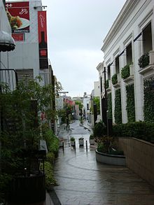
Sendagaya

Sendagaya ( Japanese 千 駄 ヶ 谷 ) is a district of the Shibuya district in the east of the Japanese prefecture of Tokyo . It is located west of central Tokyo, north of Shibuya and south of Shinjuku . The district, which is dominated by commercial and office buildings, but also criss-crossed by residential buildings, is divided into six numbered quarters, chôme , in which, according to the 2005 census, 8,498 inhabitants lived on 1.16 km², the daily population is 43,578. The postal code of Sendagaya is 151-0051.
geography
Sendagaya 1-chōme is located directly at Sendagaya Station on the Chūō line . To the north of it is a large park, the Shinjuku Gyoen, mostly in the neighboring Shinjuku district . Directly at the station is the Tōkyō Taiikukan, a venue for the 1964 Summer Olympics, and immediately to the east of it - across the district boundary in Kasumigaokamachi - is the national stadium . Next door is the Tsuda Hall , where classical concerts are given. It belongs to Tsuda University, founded in 1900 . In the southwest of 1-chōme is the Hato no Mori Hachiman-Jinja, a shrine over a thousand years old .
Further south is Sendagaya 2-chōme, which borders on the Jingū-mae ( Harajuku ) district in the south . West of Sendagaya 1 and 2 extends between the Meiji-dōri and the Yamanote line Sendagaya 3-chōme, where more and more clothing stores are located. Between the Yamanote and Chūō lines, which meet at Yoyogi station , there are some larger office buildings in Sendagaya 4-chōme. There are among other things the headquarters of the Communist Party of Japan and the Kokuritsu Nōrakudō , the "national Nō theater". To the north of the Chūō line is Sendagaya 5-chōme, which extends up to Shinjuku station in the north . The NTT Docomo Yoyogi Building and Takashimaya Times Square feature prominent high-rises here. Sendagaya 6-chōme finally comprises the southwest part of Shinjuku Gyoen .
The Onden-gawa ( 穏 田 川 ), the upper reaches of the Shibuya -gawa , which has been canalized since 1964 , originated in today's Shinjuku Gyoen and flowed through the east of today's Sendagaya from north to south. Its course is no longer visible in Sendagaya. However, its reed-covered banks gave the village its name in the 17th century: According to Shimpen Musashi Fudoki-kō ( 新編 武 蔵 風土 記 稿 ), a chronicle of the Musashi province , at a time around 1624, "a thousand [ loaded onto pack horses ] Bundle ”( 千 駄 , senda , an idiomatic expression for“ very much ” ) mown from reed grass ( 萱 , kaya ). The village was given the name Sendagaya, 千 駄 萱 , “a thousand bundles of reeds”, from which a few decades later the current spelling Sendagaya, 千 駄 ヶ 谷 , or “valley of a thousand horse loads” is said to have become.
history
Sendagaya was established as a modern community in 1889 through the merger of the villages Sendagaya, Harajuku and Onden to form the village Sendagaya ( 千 駄 ヶ 谷 村 , - mura ) in the district of South Toshima (later: the district of Toyotama ) and thus also included large parts of today's district of Jingū-mae. In 1907 Sendagaya was upgraded to a city ( machi ). According to the 1930 census, it had around 41,000 inhabitants. In 1932, Sendagaya was finally incorporated into the city of Tokyo and merged there with the cities of Yoyohata and Shibuya to form the Shibuya district. The current subdivision was created in the 1960s.
Economy and Transport
Sendagaya is home to the headquarters of several larger companies, including Nippon Seifun , the construction company Fujita , the real estate company Daikyō and Five Foxes (known for the fashion brand comme ça du mode ),
In the north run next to the Chūō line, the Shinjuku line (No. 4) of the Tokyo city highway , a prefecture street, and below it the Ōedo line of the prefectural subway . The main roads in north-south direction are the Meiji-dōri and the Gaien-nishi-dōri, which forms the eastern border of Sendagaya. The Fukutoshin line of the Tōkyō Metro runs under the Meiji-dori and stops at Kitasandō station in Sendagaya 4. In the northwest, on the Yamanote line, are the Yoyogi and Shinjuku stations, the most important transport hub in Tokyo; in the southwest, the Harajuku station is located at the the special platform for the Imperial Family is on the Sendagaya side.
Web links
Individual evidence
- ↑ Shibuya district: "Day and night population by district" ( Memento of the original from April 22, 2016 in the Internet Archive ) Info: The archive link has been inserted automatically and has not yet been checked. Please check the original and archive link according to the instructions and then remove this notice. ( MS Excel ; 34 kB)
- ↑ "Building Authority " ( kensetsu-kyoku ) of Tokyo Prefecture: Former course of the Shibuyagawa
- ↑ Shibuya District: Origin of the place names ( Memento of the original from January 12, 2014 in the Internet Archive ) Info: The archive link was inserted automatically and has not yet been checked. Please check the original and archive link according to the instructions and then remove this notice.
Coordinates: 35 ° 41 ' N , 139 ° 43' E


