Sender Heidelberg-Wieblingen
|
Sender Heidelberg-Wieblingen
|
||
|---|---|---|
| Basic data | ||
| Place: | Heidelberg | |
| Country: | Baden-Württemberg | |
| Country: | Germany | |
| Altitude : | 108 m above sea level NHN | |
| Coordinates: 49 ° 25 ′ 58.1 ″ N , 8 ° 38 ′ 42.1 ″ E | ||
| Use: | Broadcasting station | |
| Mast data | ||
| Building material : | steel | |
| Total height : | 65 m | |
| Data on the transmission system | ||
| Wavebands : | AM stations , FM stations | |
| Radio : | AM broadcast , VHF broadcast | |
| Shutdown : | April 28, 2014 | |
| Position map | ||
|
|
||
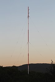
The Heidelberg-Wieblingen transmitter was a medium wave and ultra-short wave transmitter . It is located on the edge of the Heidelberg district of Wieblingen near the federal motorway 5 and about five kilometers northwest of Heidelberg city center. A guyed, self-radiating tubular steel mast, insulated from the earth, was used as the antenna carrier. The transmitter is limited by a sewage treatment plant in the north, by the Neckar in the east, by a housing estate on Sandhofer Weg in the south and by an allotment garden in the west.
From here, radio programs for the US armed forces stationed in the Heidelberg region were broadcast on medium and ultra-short waves. The transmitter was shut down on April 28, 2014.
photos
Frequencies and Programs
Analog radio (FM)
|
Frequency (in MHz) |
program | RDS PS | RDS PI | Regionalization |
ERP (in kW) |
Antenna pattern round (ND) / directional (D) |
Polarization horizontal (H) / vertical (V) |
|---|---|---|---|---|---|---|---|
| 104.6 | AFN - The Eagle | AFNEAGLE | - | Kaiserslautern | 0.375 | ND | counterclockwise |
Analog radio ( MW )
|
Frequency (kHz) |
program | Regionalization |
EMRP (kW) |
Transmission diagram round (ND) / directional (D) |
Polarization horizontal (H) / vertical (V) |
|---|---|---|---|---|---|
| 1143 | AFN - Power Network | - | 1 | ND | V |
Web links
- Photos from the transmitter Heidelberg-Wieblingen
- Information on the former medium wave transmitter Heidelberg-Wieblingen 1143 kHz ( Memento from January 23, 2010 in the Internet Archive )
Commons : Sender Heidelberg-Wieblingen - Collection of images, videos and audio files


