Sexegert lace
| Sexegert lace | ||
|---|---|---|
|
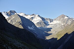
Hochvernagtspitze, Südliche Sexegertenspitze, Nördliche Sexegertenspitze, Hintere Ölgrubenspitze; in front of it left Pitztal certificate |
||
| height | 3424 m above sea level A. | |
| location | Tyrol , Austria | |
| Mountains | Ötztal Alps , Weißkamm | |
| Dominance | 0.21 km → Hochvernagtspitze | |
| Notch height | 37 m ↓ notch to the Hochvernagtspitze | |
| Coordinates | 46 ° 53 '7 " N , 10 ° 47' 34" E | |
|
|
||
| First ascent | July 29, 1887 as crossing from the Hochvernagtspitze by Heinrich Heß and Ludwig Purtscheller | |
| Normal way | from the Taschachhaus over the Wannetjoch and the north-west ridge first to the north summit , then over a firn saddle to the higher south summit . | |
The Sexegertenspitze is a mountain with two peaks in the Weißkamm of the Ötztal Alps in the Austrian state of Tyrol . The southern Sexegertenspitze has a height of 3424 meters, the northern summit is 3348 meters high. Both summit points are almost 500 meters apart, separated by a small saddle and lie under a cap of firn . Compared to the mightier Hochvernagtspitze at 3539 meters, these two peaks seem rather inconspicuous. The northern Sexegertenpitze sends out a pronounced ridge to the northwest . They were first climbed in 1887, but the neighboring Hochvernagtspitze as early as 1865.
Location and surroundings
The southern and northern Sexegertenspitze are about 10 kilometers southwest of Mittelberg, a district of the municipality of St. Leonhard im Pitztal, and 15 kilometers north of the village of Kurzras in South Tyrol . The two peaks are surrounded by glaciers . To the northeast and east lies the southern part of the extensive Sexegertenferner , whose nutrient area stretches as a firn field up over the summit points. In the west, the Wannetferner reaches up to a height of 3100 meters to the approx. 300 meter sloping west flank of the peaks, which slopes up to 50 ° . Adjacent mountains are in the south, separated without a gap or yoke , the Hochvernagtspitze, which has the geographical dominance in this area of the Weißkamm . In the course of the north-west ridge , separated by the Wannetjoch at an altitude of 3110 meters , is the rear oil pit peak with a height of 3296 meters.
Base and ascent
The two peaks were first climbed on July 29, 1887 as part of a traverse from the Hochvernagtspitze by the alpinists Heinrich Heß and Ludwig Purtscheller as part of a hike over the Weißkamm, which led from the Wildspitze to the Hinteren Ölgrubenspitze . The normal route to the two Sexegertenspitzen leads from the Taschachhaus (2434 m) in a south-westerly direction over the Sexegertenferner as an alpine tour (only with appropriate equipment and experience) to the Wannetjoch, on the north side of which, however, at times in midsummer an insurmountable bergschrund leads to detours over the Ölgrubenjoch to the north (3095 m) can force. From the Wannetjoch, the path then runs in a south-easterly direction over the northwest ridge, first to the north , then through a slight saddle up to the south of the Sexegertenspitze . According to literature, the walking time from the hut is 5 to 6 hours, depending on the conditions on the Wannetjoch. Further tours are possible through the north-east ice wall of the northern Sexegertenpitze, which slopes up to 60 ° .
Literature and map
- Walter Klier , Alpine Club Leader Ötztaler Alpen , Munich 2006, ISBN 3-7633-1123-8
- Alpine Club Map 1: 25,000, sheet 30/2, Ötztal Alps, Weißkugel

