Ariake lake
| Ariake lake | ||
|---|---|---|
|
Ariake Sea satellite image, 2007 |
||
| Waters | East China Sea | |
| Land mass | Kyushu | |
| Geographical location | 32 ° 54 ' N , 130 ° 22' E | |
|
|
||
| width | 17 km | |
| length | 90 km | |
| surface | 1 700 km² | |
| Medium water depth | 20 m | |
| Tributaries | Chikugo-gawa , Yabe-gawa , Kase-gawa , Rokkaku-gawa , Honmyō-gawa , Kikuchi-gawa , Shirakawa , Midorikawa , min. 104 more | |
The Ariake Sea ( Japanese 有 明海 , Ariake-kai ) is a bay in the East China Sea off the Japanese island of Kyushu .
geography
The bay is 90 km long, on average 17 km wide and has an area of 1700 km².
The Shimabara Peninsula protrudes east into the bay , north of it is the Isahaya Bay (( 早 湾 , Isahaya-wan ) at the mouth of the Honmyō-gawa . The southern part of the Ariake Sea from this peninsula is also called Shimabara Bay ( 島 原 湾 , Shimabara-wan ). The southern limit is formed by the Amakusa Islands , with the Yatsushiro Sea on the opposite side , which in turn is directly connected to the Ariake Sea. It is connected to the East China Sea via the Hayasaki Strait ( 早 崎 瀬 戸 , Hayasaki-seto ) between the Shimabara Peninsula and the Shimoshima Island of the Amakusa Islands , and its marine area is also called Amakusa-nada ( 天 草灘 ) at this point .
Eight class 1 rivers flow into the Ariake Sea - Chikugo-gawa , Yabe-gawa , Kase-gawa , Rokkaku-gawa , Honmyō-gawa , Kikuchi-gawa , Shirakawa and Midorikawa - with a catchment area of 6852 km² and 104 Class 2 rivers with a catchment area of 1,303.91 km². The Ariake-See thus has a total catchment area of 8155.91 km².
The Ariake Sea is relatively shallow with an average of only 20 m and also has the highest tidal range in Japan at six meters . As a result, large tidal flats with a depth of five to seven kilometers form at low tide , which in 1992 had an area of 207 km². The flood deposits around five centimeters of sediment every year.
Human use
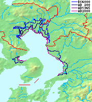
The extended watts areas to be used Nori -Anbau so that two thirds of the total Japanese production comes from here. In addition, attempts were made to drain the land for use early on, with the first such measures being documented for the reign of Empress Suiko (r. 593–628). Up until the 1970s, a total of 266 km² of new land was gained bit by bit . For these reasons, the coastline has changed significantly over the centuries and at the estuaries there are extensive fertile, but highly flood-prone plains, most of which are only up to three meters above sea level.
In the west is the Isahaya Plain ( 諫 早 平野 , Isahaya-heiya ) of Honmyō-gawa, which today extends over about 35 km² due to the 450 years of land reclamation and is the largest granary in Nagasaki Prefecture. In the north is the extensive and very water-rich Saga Plain ( 佐賀 平野 , Saga-heiya ) and in the west the Kikuchi Plain ( 菊池 平野 , Kikuchi-heiya ) of the Kikuchi-gawa, as well as the Kumamoto Plain ( 熊 本 平野 , Kumamoto- Heiya ) of the Shirakawa and Midorikawa.
Communities
The prefectures and parishes on the coast in clockwise order are:
Web links
Individual evidence
- ↑ a b c Byung Ho Choi, Takao Yamashita, Han Soo Lee: Regional Ocean Simulator: Applications to Adjacent Seas of Korea and Japan . In: Journal of International Development and Cooperation . Vol. 16, No. 2 , 2010, p. 21-38 ( hiroshima-u.ac.jp ).
- ↑ Shōji Fukuoka: 有 明海 ・ 八 代 海 に お け る 河川 の 影響 に つ い て . (PDF; 274 kB) Ministry of the Environment , accessed on October 22, 2011 (Japanese).
- ^ A b New Contingency Plan. (PDF; 1.9 MB) (No longer available online.) Takeo River Authority, MLIT , February 8, 2011, archived from the original on January 24, 2013 ; accessed on October 23, 2011 (English).
- ↑ a b 有 明海 と 諫 早 湾 の 干 拓 の 歴 史 . In: 諫 早 湾 干 拓 事業 . 農林水産省 九州 農 政局 整 備 部 (Department of Maintenance, Kyūshū Agricultural Policy Department, Ministry of Agriculture, Forestry and Fisheries ), accessed October 23, 2011 (Japanese).


