Minamishimabara
| Minamishimabara-shi 南島 原 市 |
||
|---|---|---|
|
|
||
| Geographical location in Japan | ||
| Region : | Kyushu | |
| Prefecture : | Nagasaki | |
| Coordinates : | 32 ° 40 ′ N , 130 ° 18 ′ E | |
| Basic data | ||
| Surface: | 169.89 km² | |
| Residents : | 43.006 (October 1, 2019) |
|
| Population density : | 253 inhabitants per km² | |
| Community key : | 42214-2 | |
| Symbols | ||
| Flag / coat of arms: | ||
| Tree : | Ficus superba var. Japonica | |
| Flower : | Sunflower | |
| town hall | ||
| Address : |
Minamishimabara City Hall 96 - 2 , Satobō, Nishi-chō Arie Minamishimabara -shi Nagasaki 859-1107 |
|
| Website URL: | http://www.city.minamishimabara.lg.jp/ | |
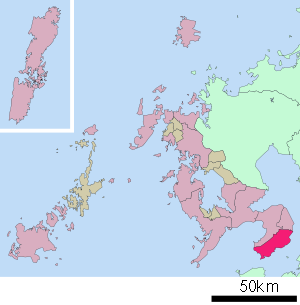
| Location of Minamishimabaras in Nagasaki Prefecture | ||
Minamishimabara ( Japanese 南島 原 市 , - shi ) is a city in Nagasaki Prefecture on the Shimabara Peninsula in Kyushu , Japan .
history
It became on March 31, 2006 by merging the communities Arie ( Ar 町 , -chō ), Fukae ( 深 江 町 , -chō ), Futsu ( 布 津 町 , -chō ), Kazusa ( 加 津 佐 町 , -chō ), Kitaarima ( 北 有 馬 町 , -chō ), Kuchinotsu ( 口 之 津 町 , -chō ), Minamiarima ( 南 有 馬 町 , -chō ) and Nishiarie ( 西 有家 町 , -chō ) of Minamitakaki County. The district ceased to exist.
traffic
- Streets:
- National road 57, 251, 389
- Train:
sons and daughters of the town
- Fumio Kyūma (* 1940), politician
Neighboring cities and communities
Web links
Commons : Minamishimabara - collection of images, videos and audio files


