Sierra Vista
| Sierra Vista | |
|---|---|
 Moon over Sierra Vista, 2011 |
|
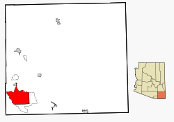
| Location in County and Arizona | |
| Basic data | |
| Foundation : | 1956 |
| State : | United States |
| State : | Arizona |
| County : | Cochise County |
| Coordinates : | 31 ° 33 ′ N , 110 ° 17 ′ W |
| Time zone : | Mountain Standard Time ( UTC − 7 ) |
|
Inhabitants : - Metropolitan Area : |
43,208 (as of 2016) 125,770 (as of 2016) |
| Population density : | 108.7 inhabitants per km 2 |
| Area : | 397.5 km 2 (approx. 153 mi 2 ) of which 397.4 km 2 (approx. 153 mi 2 ) are land |
| Height : | 1412 m |
| Postcodes : | 85600-85699 |
| Area code : | +1 520 |
| FIPS : | 04-66820 |
| GNIS ID : | 0011284 |
| Website : | www.sierravistaaz.gov |
| Mayor : | Robert Strain |
Sierra Vista is a city in Cochise County in the US state of Arizona with 43,320 inhabitants (as of 2008 ). The urban area has a size of 397.5 km². Sierra Vista is about 100 kilometers southeast of the city of Tucson and 20 kilometers north of the Mexican border. In the city there is a branch of the Tucson-based University of Arizona , called UA South . Northwest of the city is Fort Huachuca , a large United States Army base .
Sierra Vista has had a town partnership with Radebeul , Germany , since 1998 .
Population development
| year | Residents¹ |
|---|---|
| 1980 | 24,937 |
| 1990 | 32,983 |
| 2000 | 37,775 |
| 2010 | 45.140 |
| 2016 | 43.208 |
¹ 1980–2010: census results; 2016: Update of the US Census Bureau;
traffic
Sierra Vista is at the junction between Arizona State Route 90 and Arizona State Route 92 and also has an airport with the Sierra Vista Municipal Airport .
sons and daughters of the town
- Dani Siciliano , musician and DJ
- Nicole Powell (* 1982), basketball player
Web links
Commons : Sierra Vista - collection of pictures, videos and audio files
Individual evidence
- ↑ a b Population figures 2000 to 2008 ( Memento of November 17, 2011 in the Internet Archive ). Retrieved February 7, 2010.
