Sierra de Albarracín
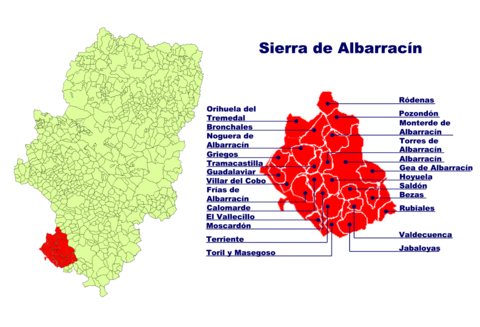
The Sierra de Albarracín is a mountain range of the Iberian Mountains , which forms a comarca ( administrative unit ) of the autonomous region of Aragon in Spain . The area is located in southwest Aragon in the province of Teruel . The comarca covers an area of 1,414 km² and has 4,961 inhabitants. The capital is Albarracín , the largest of the 25 associated municipalities.
The Sierra de Albarracín borders in the west on the province of Guadalajara , in the north on the Comarca del Jiloca , in the east on the Comunidad de Teruel and in the south on the province of Cuenca .
Besides Albarracín include the communities Bezas , Bronchales , Calomarde , Frías de Albarracín , Gea de Albarracín , Griegos , Guadalaviar , Jabaloyas , Monterde de Albarracín , Moscardón , Noguera de Albarracín , Orihuela del Tremedal , Pozondón , Ródenas , Royuela , Rubiales , Saldón , Terriente , Toril y Masegoso , Torres de Albarracín , Tramacastilla , Valdecuenca , El Vallecillo and Villar del Cobo to the comarca.

The main industries in the comarca are livestock and forestry .
In terms of cultural heritage, the capital Albarracín stands out, with a cathedral and a former castle with long walls. There are also cave paintings in the area that are between 6,000 and 1,500 years old. On their honeymoon, Crown Prince Felipe and Leticia Ortiz visited Albarracín.

