
Albarracín
| Albarracín municipality | |||
|---|---|---|---|
 Albarracín - Cathedral, town and city wall (muralla)
|
|||
| coat of arms | Map of Spain | ||
.svg)
|
|
||
| Basic data | |||
| Autonomous Community : |
|
||
| Province : | Teruel | ||
| Comarca : | Sierra de Albarracín | ||
| Coordinates | 40 ° 24 ′ N , 1 ° 27 ′ W | ||
| Height : | 1182 msnm | ||
| Area : | 452.72 km² | ||
| Residents : | 1,025 (Jan 1, 2019) | ||
| Population density : | 2.26 inhabitants / km² | ||
| Postal code : | 44100 | ||
| Municipality number ( INE ): | 44009 | ||
| administration | |||
| Website : | Albarracín | ||


Albarracín is a small town and capital of a municipality ( municipio ) with 1,025 inhabitants (as of January 1, 2019) in the province of Teruel in the autonomous region of Aragon in eastern Spain . The place is recognized as a cultural asset ( Bien de Interés Cultural ) in the category Conjunto histórico-artístico ; it is on the Camino del Cid . The city was the seat of a bishop until 1851 .
Location and climate
The place Albarracín is located on a rock in the southeast of the Iberian Mountains, almost completely surrounded by the Río Guadalaviar, about 275 km (driving distance) east of Madrid or almost 40 km west of the city of Teruel at an altitude of about 1150 to 1185 m . The climate is temperate to warm; Rain (approx. 500 mm / year) falls over the year.

Population development
| year | 1857 | 1900 | 1950 | 2000 | 2017 |
| Residents | 1,883 | 1,897 | 1,467 | 1,055 | 1,044 |
The mechanization of agriculture as well as the abandonment of small farms and the resulting loss of jobs led to a significant population decline ( rural exodus ) in the second half of the 20th century .
economy
For centuries the community lived exclusively from growing grain ( barley and wheat ), which was mainly operated for self-sufficiency ; livestock farming (sheep, goats, chickens) also took place to a small extent. The place Albarracín served as a mercantile, artisanal and cultural center for the hamlets and farmsteads in its area, which have now mostly disappeared. Today agriculture still plays the most important role, but there is also income from tourism (rental of holiday homes, etc.).
history
In the 1st millennium BC Celtiberian tribal groups of the Lobetans probably settled in the region . In Roman times there was a country estate ( villa rustica ) and perhaps also a small place called Lobetum ; In addition, the Romans dug an approx. 16 km long aqueduct to the neighboring town of Cella . The Visigoths built a church dedicated to the Virgin Mary . During the period of the gradual collapse of the Caliphate of Cordoba , the Berber dynasty of the Banu Racin founded a short-lived Taifa emirate , from which the city received its current name. The emirate existed from 1012 to 1104; his emirs were:
- Hudayl Djalaf 'Izz ad-Dawla, 1012-1045
- Abu Marwan 'Abd al-Malik, 1045-1103
- Yahya Husam ad-Dawla, 1103-1104
After that, Albarracín became part of the empire of the Berber Almoravids , who were followed by the Almohads around the middle of the 12th century . These were expelled from the Iberian Peninsula after the battle of Las Navas de Tolosa (1212). Albarracín fell into the hands of the Christians without a fight - first to the Azagra family , later to the Lara family and finally (around 1300) to the Crown of Aragón .
Attractions

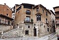
- The old town of Albarracín with its winding streets and houses made of stone, clay and half-timbered houses was already classified as Conjunto histórico-artístico in 1961 .
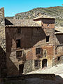
- The city wall, stabilized and secured by angular and semicircular towers, was built in the 14th century. Their enormous size suggests that renewed attacks were expected; It also made it possible for farmers to take up with their cattle and for a significant expansion of the city, which, however, did not take place.
- The Alcázar is a free-standing part of the city fortifications and dates from the 10th century. From 1088 to 1093, El Cid negotiated with the prince who lived here. In Christian times it was redesigned and provided with semicircular towers. Today there is a small ceramic museum here.
- The Catedral de El Salvador , built between 1572 and 1600, was built on the site of a previous Romanesque building; other structural changes date from the baroque period . The elaborately vaulted apse contains a carved altar from 1566 with almost life-size figures.
- The bishop's palace (palacio episcopal) was built around the same time; he too experienced numerous structural changes. Today the Diocesan Museum (Museo Diocesano) is located here with numerous exhibits from different centuries.
- The city museum (Museo de Albarracín) is located in the former hospital from the 18th century; it presents objects from the different epochs of the city's history.

Part of the Roman aqueduct (acueducto)

Houses and city walls
Alleys and houses of the old town

dto.

dto.
Casa de los Navarro Arzuriaga


- Surroundings
- Several rock overhangs ( abris ) in the vicinity contain prehistoric rock carvings of bulls etc.
Web links
- Albarracín, sights - photo + info (Spanish)
- Albarracín, Camino del Cid - Photo + Info (Spanish)
- INE: National Statistical Agency
- Taifa Emirates and their rulers ( Memento from May 1, 2008 in the Internet Archive )
Individual evidence
- ↑ Cifras oficiales de población resultantes de la revisión del Padrón municipal a 1 de enero . Population statistics from the Instituto Nacional de Estadística (population update).
- ↑ Albarracín - climate tables
- ^ Albarracín - population development
- ↑ Albarracín - History
- ^ Albarracín - Alcázar
- ↑ Abarracín - Cathedral
- ^ Albarracín - Episcopal Palace and Diocesan Museum

Ababuj | Abejuela | Aguatón | Aguaviva | Aguilar del Alfambra | Alacón | Alba | Albalate del Arzobispo | Albarracín | Albentosa | Alcaine | Alcalá de la Selva | Alcañiz | Alcorisa | Alfambra | Aliaga | Allepuz | Alloza | Allueva | Almohaja | Alobras | Alpeñés | Anadón | Andorra | Arcos de las Salinas | Arens de Lledó | Argente | Ariño | Azaila | Bádenas | Báguena | Bañón | Barrachina | Bea | Beceite | Bello | Belmonte de San José | Mountains | Bezas | Blancas | Blesa | Bordón | Bronchales | Bueña | Burbáguena | Cabra de Mora | Calaceite | Calamocha | Calanda | Calomarde | Camañas | Camarena de la Sierra | Camarillas | Caminreal | Cantavieja | Cañada de Benatanduz | La Cañada de Verich | Cañada Vellida | Cañizar del Olivar | Cascante del Río | Castejón de Tornos | Castel de Cabra | Castellote | Castelnou | Castelserás | Cedrillas | Celadas | Cella | Corbalán | Cortes de Aragón | Cosa | Cretas | Crivillén | Cubla | Cucalón | Cuevas de Almudén | Cuevas Labradas | Ejulve | El Pobo | El Castellar | El Cuervo | El Vallecillo | Escorihuela | Escucha | Estercuel | Ferreruela de Huerva | Fonfría | Formiche Alto | Fórnoles | Fortanete | Foz-Calanda | Frías de Albarracín | Fuenferrada | Fuentes Calientes | Fuentes Claras | Fuentes de Rubielos | Fuentespalda | Galve | Gargallo | Gea de Albarracín | Griegos | Guadalaviar | Gúdar | Híjar | Hinojosa de Jarque | Huesa del Común | Jabaloyas | Jarque de la Val | Jatiel | Jorcas | Josa | La Cerollera | La Codoñera | La Cuba | La Fresneda | La Ginebrosa | Lagueruela | La Hoz de la Vieja | La Iglesuela del Cid | La Mata de los Olmos | Lanzuela | La Portellada | La Puebla de Híjar | La Puebla de Valverde | Las Parras de Castellote | La Zoma | Libros | Lidón | Linares de Mora | Loscos | Lot Olmos | Lledó | Maicas | Manzanera | Martín del Río | Mas de las Matas | Mazaleón | Mezquita de Jarque | Mirambel | Miravete de la Sierra | Molinos | Monforte de Moyuela | Monreal del Campo | Monroyo | Montalbán | Monteagudo del Castillo | Monterde de Albarracín | Mora de Rubielos | Moscardón | Mosqueruela | Muniesa | Noguera de Albarracín | Nogueras | Nogueruelas | Obón | Odón | Ojos Negros | Olba | Oliete | Orihuela del Tremedal | Orrios | Palomar de Arroyos | Pancrudo | Peñarroya de Tastavins | Peracense | Peralejos | Perales del Alfambra | Pitarque | Plou | Pozondón | Pozuel del Campo | Puertomingalvo | Ráfales | Rillo | Riodeva | Ródenas | Royuela | Rubiales | Rubielos de la Cérida | Rubielos de Mora | Salcedillo | Balance | Samper de Calanda | San Agustín | San Martín del Río | Santa Cruz de Nogueras | Santa Eulalia del Campo | Sarrión | Segura de los Baños | Seno | Singra | Terriente | Teruel | Toril y Masegoso | Tormón | Tornos | Torralba de los Sisones | Torre de Arcas | Torre de las Arcas | Torre del Compte | Torre los Negros | Torrecilla de Alcañiz | Torrecilla del Rebollar | Torrelacárcel | Torremocha de Jiloca | Torres de Albarracín | Torrevelilla | Torrijas | Torrijo del Campo | Tramacastiel | Tramacastilla | Tronchón | Urrea de Gaén | Utrillas | Valacloche | Valbona | Valdealgorfa | Valdecuenca | Valdelinares | Valdeltormo | Valderrobres | Valjunquera | Veguillas de la Sierra | Villafranca del Campo | Villahermosa del Campo | Villanueva del Rebollar de la Sierra | Villar del Cobo | Villar del Salt | Villarluengo | Villarquemado | Villarroya de los Pinares | Villastar | Villel | Vinaceite | Visiedo | Vivel del Río Martín