Fonfría (Teruel)
| Fonfría municipality | ||
|---|---|---|
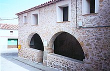
 Fonfría - town view
|
||
| coat of arms | Map of Spain | |
 Help on coat of arms |
|
|
| Basic data | ||
| Autonomous Community : |
|
|
| Province : | Teruel | |
| Comarca : | Comarca del Jiloca | |
| Coordinates | 41 ° 0 ′ N , 1 ° 5 ′ W | |
| Height : | 1245 msnm | |
| Area : | 20.58 km² | |
| Residents : | 27 (Jan. 1, 2019) | |
| Population density : | 1.31 inhabitants / km² | |
| Postal code : | 44492 | |
| Municipality number ( INE ): | 44102 | |
| administration | ||
| Website : | Fonfría | |
Fonfría is a place and a municipality (municipio) with only 27 inhabitants (as of January 1, 2019) in the province of Teruel in the autonomous region of Aragon in the eastern center of Spain . The municipality belongs to the poorly populated Serranía Celtibérica and was part of the municipality of Allueva , located about six kilometers to the east, until the 1920s .
Location and climate
The place Fonfría is located in the mountains of the Sierra de Cucalón near the source of the Río Huerva at an altitude of approx. 1245 m and is approx. 100 km (driving distance) to the north from the provincial capital Teruel . Despite the altitude, the climate is temperate to warm; Rain (approx. 530 mm / year) falls over the year.
Population development
| year | 1857 | 1900 | 1930 | 2000 | 2017 |
| Residents | - | - | 209 | 32 | 30th |
The mechanization of agriculture and the task of rural small businesses and the resulting loss of jobs have to since the mid-20th century rural exodus out.
economy
Fonfría is traditionally agriculturally oriented, with cattle breeding playing the largest role. Craftsmen had also settled in the village. Tourism in the form of renting out holiday homes hardly plays a role.
history
Celtiberian , Roman , Visigoth and even Moorish traces have not yet been discovered. It is believed that the area was previously only used by transhumants as summer pasture for cattle and that sedentaration only gradually took place. In 1205 the area belonged to the Comunidad de Daroca .
Attractions
- The church of San Miguel Arcangel is one of broken stones erected building of the 18th century. The upper part of the bell tower (campanar) , on the other hand, is made of bricks and has clear echoes of the Mudejar style . The three-aisled church, vaulted with stitches, preserves the baptismal font (pila) of a previous building and several baroque altarpieces (retablos) .
- A kind of " portico " is integrated into the ground floor of the town hall (ayuntamiento) .
- Surroundings
- The Ermita Virgen de la Silla stands on a hill about two kilometers outside the village. The history of the building may begin as early as the 13th century, but changes have been made again and again.
Web links
Individual evidence
- ↑ Cifras oficiales de población resultantes de la revisión del Padrón municipal a 1 de enero . Population statistics from the Instituto Nacional de Estadística (population update).
- ↑ Fonfría - Climate tables
- ↑ Fonfría - Population Development
- ↑ Fonfría - Church
- ↑ Fonfría - Church
- ↑ Fonfría - Ermita


