El Castellar
| El Castellar municipality | ||
|---|---|---|
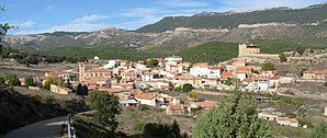
 El Castellar - town view
|
||
| coat of arms | Map of Spain | |

|
|
|
| Basic data | ||
| Autonomous Community : |
|
|
| Province : | Teruel | |
| Comarca : | Gúdar-Javalambre | |
| Coordinates | 40 ° 22 ′ N , 0 ° 49 ′ W | |
| Height : | 1275 msnm | |
| Area : | 50.33 km² | |
| Residents : | 58 (Jan. 1, 2019) | |
| Population density : | 1.15 inhabitants / km² | |
| Postal code : | 44409 | |
| Municipality number ( INE ): | 44070 | |
| administration | ||
| Website : | El Castellar | |
El Castellar is a place and a municipality ( municipio ) with 58 inhabitants (as of January 1, 2019) in the south of the province of Teruel in the autonomous region of Aragon in eastern central Spain .
Location and climate
The place El Castellar is located in the headwaters of the Río Mijares in the south of the Iberian Mountains about 41 km (driving distance) east of the city of Teruel at an altitude of about 1240 to 1275 m . The climate is temperate to warm; Rain (approx. 545 mm / year) falls over the year.
Population development
| year | 1857 | 1900 | 1950 | 2000 | 2017 |
| Residents | 491 | 459 | 379 | 97 | 54 |
The mechanization of agriculture as well as the abandonment of small farms and the resulting loss of jobs led to a significant population decline ( rural exodus ) in the second half of the 20th century .
economy
For centuries the community lived exclusively from growing grain ( barley and wheat ), which was mainly operated for self-sufficiency ; livestock farming (sheep, goats, chickens) also took place to a small extent. The place El Castillar served as a mercantile, artisanal and cultural center for the hamlets (pedanías) and individual farms (fincas) in its vicinity, which have now mostly disappeared . Today agriculture still plays the most important role; There is hardly any income from tourism.
history
In the 1st millennium BC Celtiberian tribal groups of the Lobetans probably settled in the region . Roman , Visigoth and Moorish traces have not yet been discovered. About 30 years after Teruel had been conquered in 1170/71, the town of El Castellar was founded, the area of which had previously only been used as summer pasture .
Attractions
- Numerous dinosaur tracks have been discovered in the region .
- The castle (castillo) originally dates from the 13th century; However, it was rebuilt several times due to damage during the Carlist Wars (19th century) and is now privately owned.
- The Ermita de Santa Bárbara is in the immediate vicinity of the castle; it may have served as the town's first parish church.
- The Church of San Miguel is dedicated to the Archangel Michael. The late Gothic building was built around the middle of the 16th century; the single-nave interior, however , with side chapels , was redesigned in Baroque style in the 18th century . The nave has a stitch cap vault ; the chapels have been converted into groin-vaulted aisles.
- Surroundings
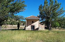
- About three kilometers outside the village is the Ermita de la Virgen del Pilar .
Web links
Individual evidence
- ↑ Cifras oficiales de población resultantes de la revisión del Padrón municipal a 1 de enero . Population statistics from the Instituto Nacional de Estadística (population update).
- ↑ El Castellar - climate tables
- ↑ El Castellar - population development
- ↑ El Castillar - Castillo
- ↑ El Castillar - Castillo
- ↑ El Castellar - Church


