
Sigriswilgrat
| Sigriswiler Rothorn | ||
|---|---|---|
 Sigriswiler Rothorn from the Justistal seen |
||
| height | 2051 m above sea level M. | |
| location | Canton of Bern , Switzerland | |
| Mountains | Emmental Alps | |
| Dominance | 2.1 km → Burgfeldstand | |
| Notch height | 372 m ↓ sickle | |
| Coordinates | 625 372 / 175 554 | |
|
||

The Sigriswilgrat , even against the map of Switzerland as Sigriswilergrat called, is a mountain ridge with several summits of the Emmental Alps in the canton of Bern in Switzerland . Its main peak is the Sigriswiler Rothorn ( 2051 m above sea level ).
location
The mountain ridge is about 12 km east of Thun (as the crow flies). The communities Sigriswil and Horrenbach-Buchen have a share in the Sigriswilergrat .
The striking Sigriswilergrat stretches from Lake Thun near Merligen for around 7 km to the northeast to the edge of the Zulg Valley . Important peaks from southwest to northeast are the Fluh peak ( 1658 m above sea level ), the Merra ( 1954 m above sea level ), the main summit Sigriswiler Rothorn 2051 m above sea level. M. , the Mittaghorn ( 2014 m above sea level ), the Schaflagerzähne ( 1952 m above sea level ) and the Burst ( 1969 m above sea level ).
The Sigriswilergrat slopes steeply to the south-east to the Justistal , the head of which lies on the Sichelpass and which separates it from the Güggisgrat chain, which runs parallel to the south-east, and from the Sieben Hengsten . To the northwest, too, the mountain range with numerous rock faces drops steeply to the alpine region and to the wooded hill country east of Thun. At the foothill of the boundary runs the Swiss Central Plateau . The mountain area is developed with mountain hiking trails, some of which lead through difficult terrain and are only suitable for experienced mountain hikers.
In the Sigriswilergrat there is a former natural ice cave, the Schafloch . It was expanded as a Schafloch lock and enables the crossing under the Sigriswiler Rothorn from the Justistal to the Zettelalp.
geology
From a geological point of view, the Sigriswilergrat is made up of sediments from the Helvetic Mountains, which were deposited around 225 to 65 million years ago on the northern edge of the ancient Mediterranean Sea, Tethys . These layers were only included in the folding of the Alps relatively late, around 20 million years ago. The rugged rock walls in the upper part of the Sigriswilergrat are made of Schrattenkalk . This is followed by marly and chalky series of the Drusberg layers and of silica limestone. These are sediments from the Cretaceous Period . At the foot of the ridge , flysch and marl of the ultrahelvetic are exposed. The ridge area shows an alternation of alpine lawns and rocky areas covered by cart fields or rubble.
Summit documentation
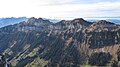
Western part of the Sigriswilergrat with Sigriswiler Rothorn and Mittaghorn

Eastern part of the Sigriswilergrat with sheep teeth and burst

Sigriswilgrat in spring, seen from Spiez

Pointed Fluh


