Sintar
|
Sintar Buchberg Bükkhegy |
||||
|
||||
| Basic data | ||||
|---|---|---|---|---|
| State : |
|
|||
| Historical region : | Banat | |||
| Circle : | Timiș | |||
| Municipality : | Bogda | |||
| Coordinates : | 45 ° 59 ' N , 21 ° 36' E | |||
| Time zone : | EET ( UTC +2) | |||
| Residents : | 16 (2002) | |||
| Postal code : | 307076 | |||
| Telephone code : | (+40) 02 56 | |||
| License plate : | TM | |||
| Structure and administration | ||||
| Community type : | Village | |||
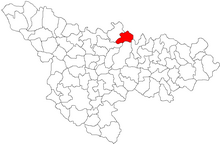
Sintar (1924: Sântari , German: Buchberg , Hungarian: Bükkhegy ) is a village in Timiș County , Banat , Romania . The village of Sintar is part of the Bogda municipality .
Geographical location
Sintar is located in the north of Timiș County, in the Lipova Hills, two kilometers from the Bogda municipality, on the DJ691A Mașloc - Topolovățu Mare county road .
Neighboring places
| Zăbrani | Chesinț | Neudorf |
| Bogda |

|
Comeat |
| Buzad | Stanciova | Hodoș |
history
In 1455 a village in the area of today's Sintar was first mentioned under the name of Zenthi . The settlement was devastated and destroyed during the Turkish Wars and only reappeared on the Mercy map of 1723.
The place Buchberg was founded in 1770–1771 by the Temescher Landesadministrationrat Franz Carl Samuel Neumann Edler von Buchholt through the settlement of 32 German families from Baden-Württemberg, Bavaria and the Palatinate. The name of the place derives from Eduard von Buchberg, the secretary of the administration president Clary-Altringen. The Hungarian name Bükkhegy is the translation of the German Buchberg (Hungarian: Bükk = beech, Hegy = mountain). The Romanian name Sintar goes back to the medieval Szenti . At the same time, Neumann also laid out the villages of Altringen , named after the President Count von Clary and Altringen, and Charlottenburg , named after his wife, which also belong to the Bogda community .
On June 4, 1920, the Banat was divided into three parts as a result of the Treaty of Trianon . The largest, eastern part, to which Buchberg also belonged, fell to the Kingdom of Romania . Since then, Sintar has been the official place name.
The last landowner of Buchberg was Lajos von Szabo, who was expropriated after the land reform of 1921. The field property was parceled out and sold to the farmers in the village.
Buchberg was surrounded by large areas of forest and had a forester's house. The forests around Buchberg were very rich in game, so large hunts were organized here, in which hunters from the area and Timisoara took part.
Demographics
| census | Ethnicity | |||||||
|---|---|---|---|---|---|---|---|---|
| year | Residents | Romanians | Hungary | German | Other | |||
| 1880 | 280 | 117 | - | 162 | 1 | |||
| 1910 | 327 | 163 | 7th | 157 | - | |||
| 1930 | 281 | 162 | 2 | 113 | 4th | |||
| 1977 | 41 | 37 | - | 3 | 1 | |||
| 2002 | 16 | 15th | - | 1 | - | |||
literature
- Elke Hoffmann, Peter-Dietmar Leber and Walter Wolf : The Banat and the Banat Swabians. Volume 5. Cities and Villages , Media Group Universal Grafische Betriebe München GmbH, Munich, 2011, 670 pages, ISBN 3-922979-63-7
Web links
- banater-aktualitaet.de , Anton Zollner: Through the Bergsau
Individual evidence
- ^ A b c Elke Hoffmann, Peter-Dietmar Leber and Walter Wolf : The Banat and the Banat Swabians. Volume 5. Cities and Villages , Media Group Universal Grafische Betriebe München GmbH, Munich, 2011, 670 pages, ISBN 3-922979-63-7
- ↑ banater-aktualitaet.de , Anton Zollner: Through the mountain sow
- ↑ kia.hu , (PDF; 982 kB) E. Varga: Statistics of the number of inhabitants by ethnic group in the Timiș district according to censuses from 1880 - 2002


