Topolovățu Mare
|
Topolovățu Mare Large Toplowetz Nagytopoly |
||||
|
||||
| Basic data | ||||
|---|---|---|---|---|
| State : |
|
|||
| Historical region : | Banat | |||
| Circle : | Timiș | |||
| Coordinates : | 45 ° 46 ' N , 21 ° 37' E | |||
| Time zone : | EET ( UTC +2) | |||
| Residents : | 2,574 (2011) | |||
| Postal code : | 307420 | |||
| Telephone code : | (+40) 02 56 | |||
| License plate : | TM | |||
| Structure and administration (as of 2016) | ||||
| Community type : | local community | |||
| Structure : | Topolovățu Mare, Cralovăț , Ictar-Budinț , Iosifalău , Șuştra , Topolovățu Mic | |||
| Mayor : | Doța Ovidiu-Petru (Alianța pentru Viitor) | |||
| Postal address : | Str. Principală, no. 321 loc. Topolovățu Mare, jud. Timiș, RO-307420 |
|||
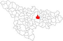
Topolovățu Mare (German: Großtoplowetz , Hungarian: Nagytopoly ) is a municipality in Timiș County , in the Banat region , in southwest Romania . The Topolovățu Mare municipality also includes the villages of Cralovăț , Ictar-Budinț , Iosifalău , Șuştra and Topolovățu Mic .
Geographical location
Topolovățu Mare is located in the middle of Timiș County, on the DN6 national road , halfway between Timișoara and Lugoj , on the right Begaufer .
Neighboring places
| Șuştra | Cralovăț | Ghizela |
| Bazoșu Nou |

|
Iosifalau |
| Bazoș | Racovița | Topolovățu Mic |
history
The place Topolovăț was first mentioned in a Turkish script in 1554. At the time of the Josephine land survey of 1717, the place was called Topolovac and had 40 houses. Thanks to the favorable traffic situation at the Timișoara-Lugoj and Buziaș - Lipova intersection , there was a post office in Topolovăț in 1767.
Work on the Bega Canal began in 1728. To regulate the Bega, the Dutch engineer Max Fremaut put on ship lifts in Topolovăț and Coşteiu between 1758 and 1760 . Labor camps were created to secure the manpower needed to build the lifts. This is how Topolovățu Mic and Coşteiu Mic were born . For the time being, Topolovățu Mic belonged to Topolovățu Mare. Topolovățu Mic has been an independent village since 1828.
The Treaty of Trianon on June 4, 1920 resulted in the triple division of the Banat , whereby Topolovățu Mare fell to the Kingdom of Romania .
Demographics
The population development of the municipality of Topolovățu Mare:
| census | Ethnicity | |||||||
|---|---|---|---|---|---|---|---|---|
| year | Residents | Romanians | Hungary | German | Other | |||
| 1880 | 5277 | 4182 | 107 | 139 | 849 | |||
| 1910 | 6244 | 3899 | 299 | 1171 | 875 | |||
| 1930 | 5247 | 3393 | 150 | 827 | 877 | |||
| 1977 | 4140 | 3100 | 90 | 336 | 614 | |||
| 2002 | 2971 | 2510 | 62 | 28 | 371 | |||
Web links
- ghidulprimariilor.ro , Topolovățu Mare Citizens Registration Office
- cjtimis.ro , Timiș District Office: Topolovățu Mare
Individual evidence
- ↑ Mayoral elections 2016 in Romania ( MS Excel ; 256 kB)
- ↑ kia.hu , (PDF; 982 kB) E. Varga: Statistics of the number of inhabitants by ethnic group in the Timiș district according to censuses from 1880 - 2002


