Charlottenburg (Banat)
|
Charlottenburg Charlottenburg Saroltavár |
||||
|
||||
| Basic data | ||||
|---|---|---|---|---|
| State : |
|
|||
| Historical region : | Banat | |||
| Circle : | Timiș | |||
| Municipality : | Bogda | |||
| Coordinates : | 45 ° 59 ' N , 21 ° 31' E | |||
| Time zone : | EET ( UTC +2) | |||
| Height : | 165 m | |||
| Residents : | 111 (2002) | |||
| Postal code : | 307073 | |||
| Telephone code : | (+40) 02 56 | |||
| License plate : | TM | |||
| Structure and administration (as of 2012) | ||||
| Community type : | Village | |||
| Mayor : | Luca Dorel ( USL ) | |||
Charlottenburg or Charlotenburg ( Romanian Șarlota ; Hungarian Saroltavár ) is a village in western Romania, in the Romanian Banat . It is located at an altitude of 165 m in the Timiș County on the western slope of the Romanian Western Carpathians . Charlottenburg belongs to the municipality of Bogda (German: Neuhof) and has around 200 inhabitants.
The religious affiliation of the German population is or was Roman Catholic. A Rhine Franconian fescht dialect is or was spoken.
location
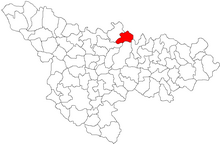
Charlottenburg is located in western Romania, in the Timis district and belongs to the Bogda municipality .
Neighboring places
| Mașloc | Alioș | Zăbrani |
| Fibiș |

|
Altringen |
| Pișchia | Recaș | Ghizela |
history
In 1718 - after the Passarowitz peace treaty - the Banat was annexed to Austria-Hungary after 164 years of Turkish occupation and, as the imperial crown and chamber domain, was subordinated to the Viennese government. After that, German colonists were settled in the Banat; they came in three sections, the so-called Swabian trains .
Charlottenburg, like all the villages in today's Bogda community , was built in 1771 during the Second Swabian Procession (1763–1772). These localities owe their development mainly to the Count of Clary-Aldringen, who was appointed President of the Imperial and Royal State Administration in 1769 . They were built under the supervision of Carl Samuel Neumann Edler von Buchholt , an official in the Salt Chamber Office Lipova (German: Lippa ).
As a result of the Austro-Hungarian settlement in February 1867, the Banat came under Hungarian administration internally . A huge wave of Magyarization began, which peaked at the beginning of the 20th century.
On June 4, 1920, the Banat was divided into three parts as a result of the Treaty of Trianon . The largest, eastern part, to which Charlottenburg also belonged, fell to the Kingdom of Romania .
As a result of the Waffen-SS Agreement of May 12, 1943 between the Antonescu government and Hitler's Germany , all men of German origin who were conscripted into the German army. Before the end of the war, on January 14, 1945, all ethnic German women between 18 and 30 and men between the ages of 16 and 45 were deported to the Soviet Union for reconstruction work .
The Land Reform Act of March 23, 1945 , which provided for the expropriation of German farmers in Romania, deprived the rural population of their livelihoods. The expropriated land was distributed to smallholders, farm workers and colonists from other parts of the country. The collectivization of agriculture was initiated in the early 1950s . Through the nationalization law of June 11, 1948 , which provided for the nationalization of all industrial and commercial enterprises, banks and insurance companies, the expropriation of all economic enterprises took place regardless of ethnicity.
Layout
The place is a regularly laid out round village , the only one of its kind in the Banat. The inside diameter is approx. 210 m. Francesco Griselini wrote in 1780: "I particularly like the Charlotenburg complex, which makes a circle around a mulberry plantation in the center".
Today the village looks more like an apple: round, with a kinked stem that represents the suburb. In the middle are the church, the school and another four courtyards. The village currently has 111 inhabitants. Many of the Banat Swabian houses have been converted into holiday apartments.
Demographics
| count | nationality | |||||||
|---|---|---|---|---|---|---|---|---|
| year | population | Romanians | Hungary | German | other | |||
| 1880 | 298 | 31 | 31 | 224 | 12 | |||
| 1910 | 278 | 20th | 36 | 215 | 7th | |||
| 1966 | 213 | 70 | 18th | 125 | - | |||
| 1977 | 179 | 62 | 10 | 79 | 28 | |||
| 1992 | 135 | 97 | 6th | 13 | 19th | |||
| 2002 | 111 | 99 | 1 | 6th | 5 | |||
See also
literature
- Elke Hoffmann, Peter-Dietmar Leber and Walter Wolf : The Banat and the Banat Swabians. Volume 5. Cities and Villages , Media Group Universal Grafische Betriebe München GmbH, Munich, 2011, 670 pages, ISBN 3-922979-63-7 .
Web links
Individual evidence
- ↑ Varga E. Census data for Temes county 1880 - 1992 (PDF; 897 kB)


